
Hallville topographic map
Interactive map
Click on the map to display elevation.
About this map
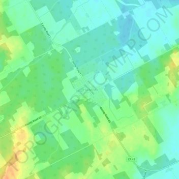
Name: Hallville topographic map, elevation, terrain.
Average elevation: 299 ft
Minimum elevation: 256 ft
Maximum elevation: 371 ft
Other topographic maps
Click on a map to view its topography, its elevation and its terrain.
Ormond
Canada > Ontario > Stormont, Dundas and Glengarry Counties > North Dundas
Ormond, North Dundas, Stormont, Dundas and Glengarry Counties, Eastern Ontario, Ontario, Canada
Average elevation: 253 ft
Timmins Drain
Canada > Ontario > Stormont, Dundas and Glengarry Counties > North Dundas
Timmins Drain, North Dundas, Stormont, Dundas and Glengarry Counties, Eastern Ontario, Ontario, Canada
Average elevation: 236 ft
Winchester
Canada > Ontario > Stormont, Dundas and Glengarry Counties > North Dundas
Winchester, North Dundas, Stormont, Dundas and Glengarry Counties, Eastern Ontario, Ontario, K0C 2K0, Canada
Average elevation: 249 ft
Chesterville
Canada > Ontario > Stormont, Dundas and Glengarry Counties > North Dundas
Chesterville, North Dundas, Stormont, Dundas and Glengarry Counties, Eastern Ontario, Ontario, K0C 1H0, Canada
Average elevation: 243 ft