Geolocate

Melzo topographic map

Click on the map to display elevation.

About this map

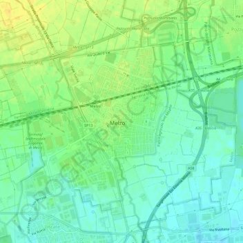
Name: Melzo topographic map, elevation, terrain.

Location: Melzo, Milan, Lombardy, 20066, Italy (45.48197 9.39540 45.51566 9.45234)

Average elevation: 387 ft

Minimum elevation: 351 ft

Maximum elevation: 433 ft

Other topographic maps

Click on a map to view its topography, its elevation and its terrain.

Monte Stella

Italy > Lombardy > Milan > Milan

Average elevation: 440 ft

Castelletto di Cuggiono

Italy > Lombardy > Milan

Average elevation: 466 ft

Fagnano

Italy > Lombardy > Milan > San Vito

Average elevation: 394 ft

Zivido

Italy > Lombardy > Milan > San Giuliano Milanese

Average elevation: 308 ft

Ospiate

Italy > Lombardy > Milan > Bollate

Average elevation: 512 ft

Mazzo

Italy > Lombardy > Milan > Rho

Average elevation: 509 ft

Cascina Confaloniera

Italy > Lombardy > Milan > Rosate

Average elevation: 351 ft

Mariotto

Italy > Lombardy > Milan > San Colombano al Lambro

Average elevation: 203 ft

Pantanedo

Italy > Lombardy > Milan > Rho > Mazzo

Average elevation: 502 ft

San Pietro all'Olmo

Italy > Lombardy > Milan > Cornaredo

Average elevation: 466 ft

Vaiano Valle

Italy > Lombardy > Milan > Milan > Vaiano Valle

Average elevation: 361 ft

Gear up for your next adventure:

🌡️Portable Weather Meter - Track weather conditions on the trail
🗻Climbing Gear Basics - Essential gear for beginner climbers
🧯Portable Fire Pit - Compact fire pit for camping spots
🏫Relief Map Kits - Hands-on tools for teaching landforms and elevation
📶Vehicle Signal Boosters - Improve reception in rural areas while driving to trailheads

As an Amazon Associate, this site earns from qualifying purchases at no extra cost to you.