
Wallace topographic map
Click on the map to display elevation.
About this map
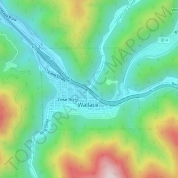
Name: Wallace topographic map, elevation, terrain.
Location: Wallace, Shoshone County, Idaho, 83873, United States (47.46761 -115.93504 47.48035 -115.90291)
Average elevation: 3,251 ft
Minimum elevation: 2,671 ft
Maximum elevation: 4,541 ft
Shoshone County trails, hiking, mountain biking, running and outdoor activities
Other topographic maps
Click on a map to view its topography, its elevation and its terrain.
Burke
United States > Idaho > Shoshone County > Mace
Burke is located about 7 miles (11 km) northeast of Wallace, at an elevation of 3,700 feet (1,130 m) above sea level. It is accessed from Wallace on Burke-Canyon Creek Road (State Highway 4). The town is located approximately 100 miles (160 km) south of the Canadian province of British Columbia, and roughly 5…
Average elevation: 4,787 ft