
Thank you for supporting this site ❤️
Make a donation
Make a donation
Gear up for your next adventure:
As an Amazon Associate, this site earns from qualifying purchases at no extra cost to you.
Pisão topographic map
Click on the map to display elevation.
Thank you for supporting this site ❤️
Make a donation
Make a donation
Gear up for your next adventure:
As an Amazon Associate, this site earns from qualifying purchases at no extra cost to you.
About this map
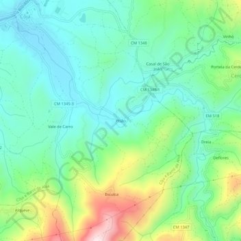
Name: Pisão topographic map, elevation, terrain.
Location: Pisão, Côja e Barril de Alva, Arganil, Coimbra, 3305, Portugal (40.23138 -7.98698 40.27138 -7.94698)
Average elevation: 1,030 ft
Minimum elevation: 574 ft
Maximum elevation: 2,159 ft
Thank you for supporting this site ❤️
Make a donation
Make a donation
Gear up for your next adventure:
As an Amazon Associate, this site earns from qualifying purchases at no extra cost to you.
Other topographic maps
Click on a map to view its topography, its elevation and its terrain.