Geolocate

Oak Harbor topographic map

Click on the map to display elevation.

About this map

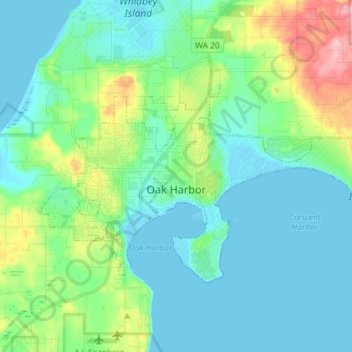
Name: Oak Harbor topographic map, elevation, terrain.

Location: Oak Harbor, Island County, Washington, United States (48.26763 -122.70024 48.32569 -122.55588)

Average elevation: 102 ft

Minimum elevation: -7 ft

Maximum elevation: 466 ft

Island County trails, hiking, mountain biking, running and outdoor activities

Other topographic maps

Click on a map to view its topography, its elevation and its terrain.

Waterloo Marsh

United States > Washington > Island County

Average elevation: 164 ft

Greenbank

United States > Washington > Island County

Average elevation: 128 ft

Gear up for your next adventure:

🦺Reflective Outdoor Gear - Safety gear for low‑light conditions
🚑Emergency Bivvies - Heat-reflective sleeping bags for survival situations
🥩Freeze-Dried Meals - Nutritious and lightweight food for remote expeditions
🛏️Cold Weather Sleeping Bag - Warm sleeping bag for cold conditions
🧥Men's Rain Shells - Premium waterproof and breathable jackets for mountain weather

As an Amazon Associate, this site earns from qualifying purchases at no extra cost to you.