
Forest City topographic map
Click on the map to display elevation.
About this map
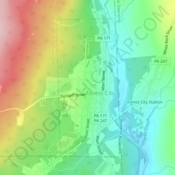
Name: Forest City topographic map, elevation, terrain.
Average elevation: 1,686 ft
Minimum elevation: 1,401 ft
Maximum elevation: 2,162 ft
Susquehanna County trails, hiking, mountain biking, running and outdoor activities
Other topographic maps
Click on a map to view its topography, its elevation and its terrain.
Stevens Point
United States > Pennsylvania > Susquehanna County > Harmony Township
Average elevation: 1,424 ft
Brackney
United States > Pennsylvania > Susquehanna County > Silver Lake Township
Average elevation: 1,611 ft
Jackson
United States > Pennsylvania > Susquehanna County > Jackson Township
Average elevation: 1,578 ft
Springville
United States > Pennsylvania > Susquehanna County > Springville Township
Average elevation: 1,276 ft
Woodhouse
United States > Pennsylvania > Susquehanna County > Dimock Township
Average elevation: 1,365 ft
Fiddle Lake
United States > Pennsylvania > Susquehanna County > Ararat Township
Average elevation: 1,998 ft
Lakeside
United States > Pennsylvania > Susquehanna County > New Milford Township
Average elevation: 1,568 ft
Elkdale
United States > Pennsylvania > Susquehanna County > Clifford Township
Average elevation: 1,519 ft
Forest Lake
United States > Pennsylvania > Susquehanna County > Forest Lake
Average elevation: 1,631 ft