Geolocate

Lenoxville topographic map

Click on the map to display elevation.

About this map

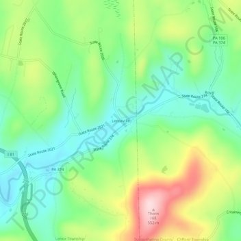
Name: Lenoxville topographic map, elevation, terrain.

Location: Lenoxville, Lenox Township, Susquehanna County, Pennsylvania, 18413, United States (41.64230 -75.65713 41.68230 -75.61713)

Average elevation: 1,247 ft

Minimum elevation: 925 ft

Maximum elevation: 1,824 ft

Other topographic maps

Click on a map to view its topography, its elevation and its terrain.

Forest City

United States > Pennsylvania > Susquehanna County

Average elevation: 1,686 ft

Montrose

United States > Pennsylvania > Susquehanna County

Average elevation: 1,604 ft

Lanesboro

United States > Pennsylvania > Susquehanna County

Average elevation: 1,198 ft

New Milford

United States > Pennsylvania > Susquehanna County

Average elevation: 1,352 ft

Montrose

United States > Pennsylvania > Susquehanna County

Average elevation: 1,604 ft

Union Dale

United States > Pennsylvania > Susquehanna County

Average elevation: 1,709 ft

Forest City

United States > Pennsylvania > Susquehanna County

Average elevation: 1,667 ft

Hallstead

United States > Pennsylvania > Susquehanna County

Average elevation: 1,060 ft

Thompson

United States > Pennsylvania > Susquehanna County

Average elevation: 1,778 ft

Gear up for your next adventure:

🛡️Insect Repellent - Protection against bugs during outdoor activities
🧭Hiking Compass - Precision compass for reliable navigation in the wilderness
🔭Compact Binoculars - HD vision for scouting terrain and identifying distant landmarks
🥩Freeze-Dried Meals - Nutritious and lightweight food for remote expeditions
🧥Men's Rain Shells - Premium waterproof and breathable jackets for mountain weather

As an Amazon Associate, this site earns from qualifying purchases at no extra cost to you.