
Make a donation
Gear up for your next adventure:
As an Amazon Associate, this site earns from qualifying purchases at no extra cost to you.
Heaters topographic map
Click on the map to display elevation.
Make a donation
Gear up for your next adventure:
As an Amazon Associate, this site earns from qualifying purchases at no extra cost to you.
About this map
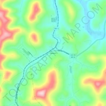
Name: Heaters topographic map, elevation, terrain.
Location: Heaters, Braxton County, West Virginia, 26627, United States (38.74120 -80.66118 38.78120 -80.62118)
Average elevation: 1,063 ft
Minimum elevation: 774 ft
Maximum elevation: 1,601 ft
Braxton County trails, hiking, mountain biking, running and outdoor activities
Make a donation
Gear up for your next adventure:
As an Amazon Associate, this site earns from qualifying purchases at no extra cost to you.
Other topographic maps
Click on a map to view its topography, its elevation and its terrain.
Burnsville Lake
United States > West Virginia > Braxton County
Construction of the Burnsville Lake project was begun in the summer of 1972 and the dam was completed in September 1976. The lake project controls the runoff from a drainage area of 165 square miles (427 km2). The dam is a rock-fill embankment dam rising 84.5 feet (25.8 m) above the streambed. Top elevation is…
Average elevation: 1,043 ft