
Make a donation
Gear up for your next adventure:
As an Amazon Associate, this site earns from qualifying purchases at no extra cost to you.
Burnsville Lake topographic map
Click on the map to display elevation.
Make a donation
Gear up for your next adventure:
As an Amazon Associate, this site earns from qualifying purchases at no extra cost to you.
Burnsville Lake
Construction of the Burnsville Lake project was begun in the summer of 1972 and the dam was completed in September 1976. The lake project controls the runoff from a drainage area of 165 square miles (427 km2). The dam is a rock-fill embankment dam rising 84.5 feet (25.8 m) above the streambed. Top elevation is 839 feet (256 m) above sea level, and the crest length is 1,400 feet (430 m). A gated spillway is located in the left abutment. The outlet works are located in the spillway section. The minimum pool is maintained at elevation 776 feet (237 m) with a surface area of 550 acres (223 ha). The summer pool is at elevation 789 feet (240 m) and has a surface area of 968 acres (392 ha). The flood control pool is at elevation 825 feet (251 m) with a surface area of 1,900 acres (769 ha).
Make a donation
Gear up for your next adventure:
As an Amazon Associate, this site earns from qualifying purchases at no extra cost to you.
About this map
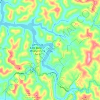
Name: Burnsville Lake topographic map, elevation, terrain.
Average elevation: 1,043 ft
Minimum elevation: 764 ft
Maximum elevation: 1,591 ft
Braxton County trails, hiking, mountain biking, running and outdoor activities
Make a donation
Gear up for your next adventure:
As an Amazon Associate, this site earns from qualifying purchases at no extra cost to you.
Other topographic maps
Click on a map to view its topography, its elevation and its terrain.
Make a donation
Gear up for your next adventure:
As an Amazon Associate, this site earns from qualifying purchases at no extra cost to you.
Little Birch
United States > West Virginia > Braxton County > Little Birch
Average elevation: 1,444 ft
Make a donation
Gear up for your next adventure:
As an Amazon Associate, this site earns from qualifying purchases at no extra cost to you.