
Mito topographic map
Interactive map
Click on the map to display elevation.
About this map
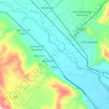
Name: Mito topographic map, elevation, terrain.
Location: Mito, Concepción, Junín, Perú (-11.95479 -75.39308 -11.90030 -75.31278)
Average elevation: 10,994 ft
Minimum elevation: 10,620 ft
Maximum elevation: 12,142 ft
Other topographic maps
Click on a map to view its topography, its elevation and its terrain.
Provincia de Concepción
Provincia de Concepción, Junín, 12125, Perú
Average elevation: 11,919 ft
Provincia de Chanchamayo
Provincia de Chanchamayo, Junín, Perú
Average elevation: 6,322 ft
San José de Quero
Perú > Junín > San José de Quero
San José de Quero, Provincia de Concepción, Junín, Perú
Average elevation: 13,589 ft
Provincia de Yauli
Provincia de Yauli, Morococha, Yauli, Junín, Perú
Average elevation: 14,993 ft