Geolocate

Hauser topographic map

Click on the map to display elevation.

About this map

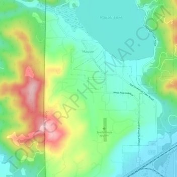
Name: Hauser topographic map, elevation, terrain.

Location: Hauser, Kootenai County, Idaho, United States (47.74605 -117.03416 47.78292 -116.99928)

Average elevation: 2,336 ft

Minimum elevation: 2,116 ft

Maximum elevation: 2,795 ft

Kootenai County trails, hiking, mountain biking, running and outdoor activities

Other topographic maps

Click on a map to view its topography, its elevation and its terrain.

Silver Sands Beach

United States > Idaho > Kootenai County

Average elevation: 2,513 ft

Fernan Saddle

United States > Idaho > Kootenai County

Average elevation: 3,940 ft

Bayview

United States > Idaho > Kootenai County

Bayview is an unincorporated community in the northwest United States, located in Kootenai County, Idaho, north of Coeur d'Alene. On the southwest shore of Lake Pend Oreille, Bayview is seven miles (11 km) east-northeast of Athol. The community is served by State Highway 54 and a post office with ZIP code…

Average elevation: 2,405 ft

Lane

United States > Idaho > Kootenai County

Average elevation: 2,408 ft

Hayden

United States > Idaho > Kootenai County

Average elevation: 2,352 ft

Cherry Hill

United States > Idaho > Kootenai County > Coeur d'Alene

Average elevation: 2,323 ft

Gear up for your next adventure:

Camping Coffee Makers - Enjoy premium coffee at the summit or campsite
🪶Survival Guide Book - Expert advice for emergency preparedness
🪶Trail Camera - Capture wildlife on your hikes
📌Outdoor GPS Map App - Apps and devices for digital topographic navigation
🏫Relief Map Kits - Hands-on tools for teaching landforms and elevation

As an Amazon Associate, this site earns from qualifying purchases at no extra cost to you.