
Make a donation
Gear up for your next adventure:
As an Amazon Associate, this site earns from qualifying purchases at no extra cost to you.
Montale topographic map
Click on the map to display elevation.
Make a donation
Gear up for your next adventure:
As an Amazon Associate, this site earns from qualifying purchases at no extra cost to you.
About this map
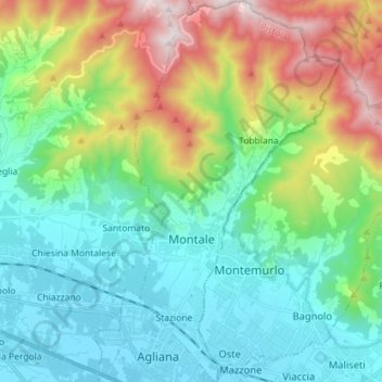
Name: Montale topographic map, elevation, terrain.
Location: Montale, Pistoia, Tuscany, 51037, Italy (43.89685 10.99451 43.99924 11.07148)
Average elevation: 1,043 ft
Minimum elevation: 131 ft
Maximum elevation: 3,376 ft
Make a donation
Gear up for your next adventure:
As an Amazon Associate, this site earns from qualifying purchases at no extra cost to you.
Other topographic maps
Click on a map to view its topography, its elevation and its terrain.
Make a donation
Gear up for your next adventure:
As an Amazon Associate, this site earns from qualifying purchases at no extra cost to you.
Pontito
Italy > Tuscany > Pistoia > Pescia
It is one of the localities called Dieci castella (Ten castles) of the Valleriana area, otherwise called Svizzera Pesciatina [it] ("Switzerland of Pescia"). It is located in the northernmost part of the Valleriana area. Pontito is an ancient village with its old stone houses in an almost total solitude,…
Average elevation: 2,480 ft
Make a donation
Gear up for your next adventure:
As an Amazon Associate, this site earns from qualifying purchases at no extra cost to you.
Make a donation
Gear up for your next adventure:
As an Amazon Associate, this site earns from qualifying purchases at no extra cost to you.
Make a donation
Gear up for your next adventure:
As an Amazon Associate, this site earns from qualifying purchases at no extra cost to you.