Geolocate

Norton topographic map

Click on the map to display elevation.

About this map

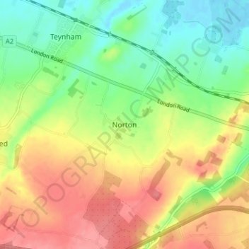
Name: Norton topographic map, elevation, terrain.

Location: Norton, Borough of Swale, Kent, England, ME9 9JU, United Kingdom (51.29657 0.80027 51.33657 0.84027)

Average elevation: 115 ft

Minimum elevation: -7 ft

Maximum elevation: 243 ft

Other topographic maps

Click on a map to view its topography, its elevation and its terrain.

Milstead

United Kingdom > England > Kent > Borough of Swale > Milstead

Average elevation: 348 ft

The Swale

United Kingdom > England > Kent > Borough of Swale

Average elevation: 39 ft

Borden

United Kingdom > England > Kent > Borough of Swale > Borden

Average elevation: 210 ft

Lower Halstow

United Kingdom > England > Kent > Borough of Swale

Average elevation: 39 ft

Newington

United Kingdom > England > Kent > Borough of Swale

Average elevation: 148 ft

Bobbing

United Kingdom > England > Kent > Borough of Swale

Average elevation: 105 ft

Newnham

United Kingdom > England > Kent > Borough of Swale > Newnham

Average elevation: 292 ft

Hernhill

United Kingdom > England > Kent > Borough of Swale > Dargate

Average elevation: 95 ft

Selling

United Kingdom > England > Kent > Borough of Swale

Average elevation: 210 ft

Faversham

United Kingdom > England > Kent > Borough of Swale

Average elevation: 56 ft

Luddenham

United Kingdom > England > Kent > Borough of Swale > Oare

Average elevation: 23 ft

Eastchurch

United Kingdom > England > Kent > Borough of Swale

Average elevation: 52 ft

Stalisfield

United Kingdom > England > Kent > Borough of Swale

Average elevation: 449 ft

Sheldwich

United Kingdom > England > Kent > Borough of Swale

Average elevation: 230 ft

Newnham

United Kingdom > England > Kent > Borough of Swale > Newnham

Average elevation: 292 ft

Luddenham

United Kingdom > England > Kent > Borough of Swale

Average elevation: 23 ft

Faversham

United Kingdom > England > Kent > Borough of Swale > Ospringe

Average elevation: 56 ft

Oare Creek

United Kingdom > England > Kent > Borough of Swale > Faversham > Oare

Average elevation: 20 ft

Iwade

United Kingdom > England > Kent > Borough of Swale

Average elevation: 20 ft

Upchurch

United Kingdom > England > Kent > Borough of Swale

Average elevation: 33 ft

Bapchild

United Kingdom > England > Kent > Borough of Swale > Bapchild

Average elevation: 69 ft

Sheerness

United Kingdom > England > Kent > Borough of Swale

Average elevation: 10 ft

Tonge

United Kingdom > England > Kent > Borough of Swale > Bapchild

Average elevation: 75 ft

Hartlip

United Kingdom > England > Kent > Borough of Swale > Hartlip

Average elevation: 230 ft

Oare

United Kingdom > England > Kent > Borough of Swale > Oare

Average elevation: 13 ft

Queenborough

United Kingdom > England > Kent > Borough of Swale

Average elevation: 7 ft

Lewson Street

United Kingdom > England > Kent > Borough of Swale > Norton

Average elevation: 118 ft

Bredgar

United Kingdom > England > Kent > Borough of Swale

Average elevation: 328 ft

Teynham

United Kingdom > England > Kent > Borough of Swale

Average elevation: 20 ft

Doddington

United Kingdom > England > Kent > Borough of Swale > Doddington

Average elevation: 338 ft

Sheerness

United Kingdom > England > Kent > Borough of Swale

Average elevation: 10 ft

Gear up for your next adventure:

💧Water Purification System - Clean water on the trail with reliable purifiers
🔌Solar Panel Charger - Charge gear sustainably outdoors
🛠️Backpacking Tool Kit - Essential toolkit for outdoor repairs
🧥Men's Rain Shells - Premium waterproof and breathable jackets for mountain weather
📦Gear Storage Bags - Organize and protect outdoor equipment

As an Amazon Associate, this site earns from qualifying purchases at no extra cost to you.