Geolocate

Clyman topographic map

Click on the map to display elevation.

About this map

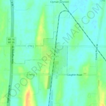
Name: Clyman topographic map, elevation, terrain.

Location: Clyman, Dodge County, Wisconsin, 53016, United States (43.30667 -88.73495 43.31759 -88.71506)

Average elevation: 899 ft

Minimum elevation: 866 ft

Maximum elevation: 974 ft

Dodge County trails, hiking, mountain biking, running and outdoor activities

Other topographic maps

Click on a map to view its topography, its elevation and its terrain.

Ashippun

United States > Wisconsin > Dodge County

Average elevation: 892 ft

Burnett

United States > Wisconsin > Dodge County

Average elevation: 892 ft

Rubicon

United States > Wisconsin > Dodge County

Average elevation: 1,040 ft

Lebanon

United States > Wisconsin > Dodge County

Average elevation: 912 ft

Gear up for your next adventure:

🚁Photography Drones - Capture stunning aerial views of landforms and topography
🪶Multi‑Purpose Knife - Useful blade for camp and trail
🌡️Portable Weather Meter - Track weather conditions on the trail
🎒Outdoor Daypacks - Lightweight backpacks designed for carrying maps and essential gear
🛰️Satellite Messengers - Emergency SOS and two-way messaging for off-grid adventures

As an Amazon Associate, this site earns from qualifying purchases at no extra cost to you.