
Make a donation
Gear up for your next adventure:
As an Amazon Associate, this site earns from qualifying purchases at no extra cost to you.
Governors Bay topographic map
Click on the map to display elevation.
Make a donation
Gear up for your next adventure:
As an Amazon Associate, this site earns from qualifying purchases at no extra cost to you.
About this map
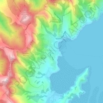
Name: Governors Bay topographic map, elevation, terrain.
Average elevation: 548 ft
Minimum elevation: -3 ft
Maximum elevation: 1,736 ft
Make a donation
Gear up for your next adventure:
As an Amazon Associate, this site earns from qualifying purchases at no extra cost to you.
Other topographic maps
Click on a map to view its topography, its elevation and its terrain.
Akaroa
New Zealand > Canterbury > Christchurch City > Banks Peninsula Community
Average elevation: 499 ft
Le Bons Bay
New Zealand > Canterbury > Christchurch City > Banks Peninsula Community
Average elevation: 801 ft
Little River
New Zealand > Canterbury > Christchurch City > Banks Peninsula Community
Average elevation: 722 ft
Okains Bay
New Zealand > Canterbury > Christchurch City > Banks Peninsula Community
Average elevation: 486 ft
Make a donation
Gear up for your next adventure:
As an Amazon Associate, this site earns from qualifying purchases at no extra cost to you.
Wainui
New Zealand > Canterbury > Christchurch City > Banks Peninsula Community
Average elevation: 666 ft
Duvauchelle
New Zealand > Canterbury > Christchurch City > Banks Peninsula Community
Average elevation: 909 ft