
Akaroa topographic map
Click on the map to display elevation.
About this map
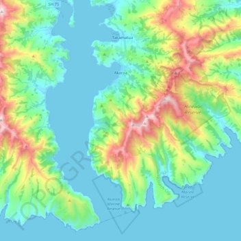
Name: Akaroa topographic map, elevation, terrain.
Average elevation: 499 ft
Minimum elevation: -7 ft
Maximum elevation: 2,585 ft
Other topographic maps
Click on a map to view its topography, its elevation and its terrain.
Lyttelton
New Zealand > Canterbury > Christchurch City > Banks Peninsula Community
Average elevation: 325 ft
Governors Bay
New Zealand > Canterbury > Christchurch City > Banks Peninsula Community
Average elevation: 548 ft
Birdlings Flat
New Zealand > Canterbury > Christchurch City > Banks Peninsula Community
Average elevation: 49 ft
Banks Peninsula
New Zealand > Canterbury > Christchurch City > Banks Peninsula Community > Pigeon Bay
Average elevation: 909 ft
Okuti Valley
New Zealand > Canterbury > Christchurch City > Banks Peninsula Community
Average elevation: 945 ft
Little River
New Zealand > Canterbury > Christchurch City > Banks Peninsula Community > Little River
Average elevation: 492 ft
Little Akaloa
New Zealand > Canterbury > Christchurch City > Banks Peninsula Community
Average elevation: 705 ft
Purple Peak Saddle
New Zealand > Canterbury > Christchurch City > Banks Peninsula Community
Average elevation: 1,572 ft
Bossu
New Zealand > Canterbury > Christchurch City > Banks Peninsula Community
Average elevation: 1,342 ft
Ōhinetahi
New Zealand > Canterbury > Christchurch City > Banks Peninsula Community > Governors Bay
Average elevation: 371 ft
Giant Totara tree
New Zealand > Canterbury > Christchurch City > Banks Peninsula Community
Average elevation: 1,253 ft