Geolocate

Røros topographic map

Click on the map to display elevation.

About this map

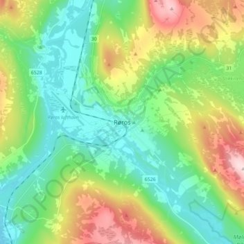
Name: Røros topographic map, elevation, terrain.

Location: Røros, Trøndelag, 7374, Norway (62.53459 11.34362 62.61459 11.42362)

Average elevation: 2,316 ft

Minimum elevation: 2,018 ft

Maximum elevation: 2,956 ft

Other topographic maps

Click on a map to view its topography, its elevation and its terrain.

Selbu

Norway > Trøndelag

Average elevation: 1,801 ft

Verdal

Norway > Trøndelag

Average elevation: 1,319 ft

Inderøy

Norway > Trøndelag

Average elevation: 509 ft

Stjørdal

Norway > Trøndelag

Average elevation: 1,030 ft

Austra

Norway > Trøndelag

Average elevation: 318 ft

Herøya

Norway > Trøndelag

Average elevation: 7 ft

Gear up for your next adventure:

❄️Traction Cleats - Prevent slips on icy trails during winter hikes
👟Men's Trail Runners - Lightweight footwear for fast-paced exploration and light hiking
📱Solar Portable Charger - Solar power bank for charging devices off‑grid
🧭Outdoor Navigation Book - Learn advanced navigation skills
📚Navigation Handbooks - Master the art of reading topographic maps and using a compass

As an Amazon Associate, this site earns from qualifying purchases at no extra cost to you.