
Make a donation
Gear up for your next adventure:
As an Amazon Associate, this site earns from qualifying purchases at no extra cost to you.
Newboro topographic map
Click on the map to display elevation.
Make a donation
Gear up for your next adventure:
As an Amazon Associate, this site earns from qualifying purchases at no extra cost to you.
About this map
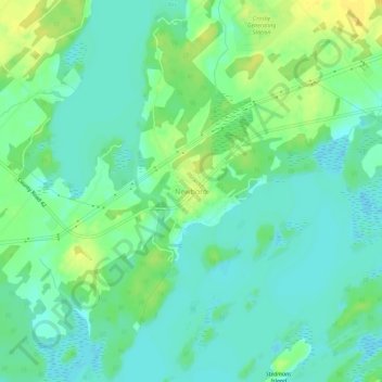
Name: Newboro topographic map, elevation, terrain.
Average elevation: 417 ft
Minimum elevation: 384 ft
Maximum elevation: 472 ft
Make a donation
Gear up for your next adventure:
As an Amazon Associate, this site earns from qualifying purchases at no extra cost to you.
Other topographic maps
Click on a map to view its topography, its elevation and its terrain.
Opinicon Lake
Canada > Ontario > Leeds and Grenville Counties > Rideau Lakes
Average elevation: 436 ft
Whitefish Lake
Canada > Ontario > Leeds and Grenville Counties > Rideau Lakes
Average elevation: 400 ft
Little Crosby Lake
Canada > Ontario > Leeds and Grenville Counties > Rideau Lakes
Average elevation: 545 ft
Upper Rideau Lake
Canada > Ontario > Leeds and Grenville Counties > Rideau Lakes > Newboro
Average elevation: 486 ft
Make a donation
Gear up for your next adventure:
As an Amazon Associate, this site earns from qualifying purchases at no extra cost to you.
Spectacle Lake
Canada > Ontario > Leeds and Grenville Counties > Rideau Lakes
Average elevation: 620 ft