
Make a donation
Gear up for your next adventure:
As an Amazon Associate, this site earns from qualifying purchases at no extra cost to you.
East Falls topographic map
Click on the map to display elevation.
Make a donation
Gear up for your next adventure:
As an Amazon Associate, this site earns from qualifying purchases at no extra cost to you.
East Falls
East Falls takes its name from its location on the east side of the Schuylkill Falls along the Schuylkill River at the original line of waterfalls known as the 'Falls of the Schuylkill' where the river descends from the elevation of the Pennsylvania piedmont to the coastal plain occupied by the main part of the City of Philadelphia. Thus East Falls was in colonial and Federalist times the highest point on the river navigable down the river by boats not driven by a skilled pilot; accordingly the settlement housed a dock and became a transfer point to the Indian path converted into colonial roadways which later became Ridge Avenue and Germantown Avenue.
Make a donation
Gear up for your next adventure:
As an Amazon Associate, this site earns from qualifying purchases at no extra cost to you.
About this map
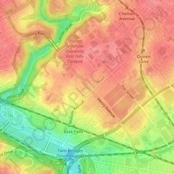
Name: East Falls topographic map, elevation, terrain.
Average elevation: 177 ft
Minimum elevation: -3 ft
Maximum elevation: 279 ft
Philadelphia County trails, hiking, mountain biking, running and outdoor activities
Make a donation
Gear up for your next adventure:
As an Amazon Associate, this site earns from qualifying purchases at no extra cost to you.
Other topographic maps
Click on a map to view its topography, its elevation and its terrain.
Pastorius Park
United States > Pennsylvania > Philadelphia County > Philadelphia
Average elevation: 354 ft
Strawberry Mansion
United States > Pennsylvania > Philadelphia County > Philadelphia
Average elevation: 102 ft
East Passyunk Community Recreation Center
United States > Pennsylvania > Philadelphia County > Philadelphia
Average elevation: 30 ft
Bartram's Garden
United States > Pennsylvania > Philadelphia County > Philadelphia
Average elevation: 43 ft
Make a donation
Gear up for your next adventure:
As an Amazon Associate, this site earns from qualifying purchases at no extra cost to you.