
Strawberry Mansion topographic map
Click on the map to display elevation.
About this map
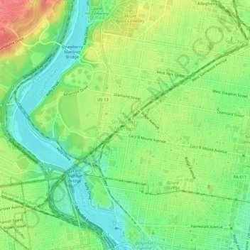
Name: Strawberry Mansion topographic map, elevation, terrain.
Average elevation: 102 ft
Minimum elevation: 3 ft
Maximum elevation: 243 ft
Philadelphia County trails, hiking, mountain biking, running and outdoor activities
Other topographic maps
Click on a map to view its topography, its elevation and its terrain.
Pastorius Park
United States > Pennsylvania > Philadelphia County > Philadelphia
Average elevation: 354 ft
Roxborough
United States > Pennsylvania > Philadelphia County > Philadelphia
Since the 1950s, most of Philadelphia's major television and FM radio stations have located their transmission towers in Roxborough because of its hilly terrain and high elevation. The tallest of these towers, the American Tower, stands approximately 1,250 feet (381m) tall. Public television station "MiND",…
Average elevation: 207 ft
East Falls
United States > Pennsylvania > Philadelphia County > Philadelphia
East Falls takes its name from its location on the east side of the Schuylkill Falls along the Schuylkill River at the original line of waterfalls known as the 'Falls of the Schuylkill' where the river descends from the elevation of the Pennsylvania piedmont to the coastal plain occupied by the main part of…
Average elevation: 177 ft
East Passyunk Community Recreation Center
United States > Pennsylvania > Philadelphia County > Philadelphia
Average elevation: 30 ft
Wissahickon Valley Park
United States > Pennsylvania > Philadelphia County > Philadelphia
Average elevation: 253 ft
Bartram's Garden
United States > Pennsylvania > Philadelphia County > Philadelphia
Average elevation: 43 ft
Chestnut Hill
United States > Pennsylvania > Philadelphia County > Philadelphia
The village of Chestnut Hill was part of the German Township laid out by Francis Daniel Pastorius and came to include the settlements originally known as Sommerhausen and Crefeld, as well as part of Cresheim. It served as a gateway between Philadelphia and the nearby farmlands. During the American…
Average elevation: 318 ft