Geolocate

Caravonica topographic map

Click on the map to display elevation.

About this map

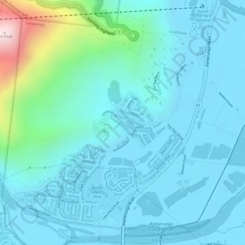
Name: Caravonica topographic map, elevation, terrain.

Location: Caravonica, Cairns, Cairns Regional, Queensland, Australia (-16.87200 145.67206 -16.84904 145.69573)

Average elevation: 299 ft

Minimum elevation: 10 ft

Maximum elevation: 1,854 ft

Other topographic maps

Click on a map to view its topography, its elevation and its terrain.

Lamb Range

Australia > Queensland > Cairns

Average elevation: 2,457 ft

Fitzroy Island

Australia > Queensland > Cairns

Average elevation: 112 ft

Walshs Pyramid

Australia > Queensland > Cairns

Average elevation: 1,050 ft

Mount Sheridan

Australia > Queensland > Cairns

Average elevation: 1,273 ft

Parramatta Park

Australia > Queensland > Cairns

Average elevation: 20 ft

Chinaman Creek

Australia > Queensland > Cairns

Average elevation: 30 ft

Gear up for your next adventure:

🧴Hand Sanitizer - Keep hands clean while hiking
🥾Hiking Shoes - Durable and comfortable shoes for trail hiking
🧭Orienteering Set - Complete compass and map reading kit
🪶Fire Starter Kit - Reliable fire starter for survival and camping
🗺️NatGeo Topo Maps - High-quality waterproof printed topographic maps of US Parks

As an Amazon Associate, this site earns from qualifying purchases at no extra cost to you.