
Make a donation
Gear up for your next adventure:
As an Amazon Associate, this site earns from qualifying purchases at no extra cost to you.
Beeby topographic map
Click on the map to display elevation.
Make a donation
Gear up for your next adventure:
As an Amazon Associate, this site earns from qualifying purchases at no extra cost to you.
Beeby
The physical and historical development of the hamlet has been strongly influenced by the local topography and its relative isolation. Beeby is situated within an established agricultural landscape largely in pastoral use. Until 1904 the east-west route was the only route through the hamlet, which was referred to as the Main Road or Barkby Road, connecting the village to Barkby (neighbouring village) and South Croxton. The other roads that now run through Beeby are Hungarton Road, situated to the east and Scraptoft Road, to the south giving the village a more direct link to the outskirts of Leicester. This isolation has mitigated the villages growth over time. This as well as several clusters of cottages and Brewery cottages mixed with informal and open grouping of farmhouses and their associating buildings are features which give this isolated village its character and appeal.
Make a donation
Gear up for your next adventure:
As an Amazon Associate, this site earns from qualifying purchases at no extra cost to you.
About this map
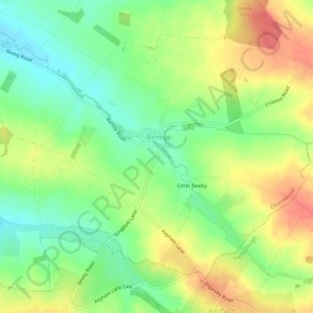
Name: Beeby topographic map, elevation, terrain.
Location: Beeby, Charnwood, Leicestershire, England, United Kingdom (52.65503 -1.04068 52.67839 -0.99153)
Average elevation: 331 ft
Minimum elevation: 236 ft
Maximum elevation: 440 ft
Make a donation
Gear up for your next adventure:
As an Amazon Associate, this site earns from qualifying purchases at no extra cost to you.
Other topographic maps
Click on a map to view its topography, its elevation and its terrain.
Swithland Wood
United Kingdom > England > Leicestershire > Charnwood > Swithland
Average elevation: 351 ft
Watermead Country Park
United Kingdom > England > Leicestershire > Charnwood > Birstall
Average elevation: 194 ft
Make a donation
Gear up for your next adventure:
As an Amazon Associate, this site earns from qualifying purchases at no extra cost to you.
Bradgate Park
United Kingdom > England > Leicestershire > Charnwood > Newtown Linford
Overlying the Beacon Hill Formation, but found a little further down the hillside to the south, are the Bradgate Formation beds, the most notable of which is the Sliding Stone Slump Breccia rocks. Forming a line of crags below Old John, these are laminated mudstones, with layers of sandstone, mainly of…
Average elevation: 413 ft
Make a donation
Gear up for your next adventure:
As an Amazon Associate, this site earns from qualifying purchases at no extra cost to you.
Top Town Plantation
United Kingdom > England > Leicestershire > Charnwood > Walton on the Wolds
Average elevation: 279 ft
Moat Hill Spinney
United Kingdom > England > Leicestershire > Charnwood > Cotes
Average elevation: 164 ft
Lea Wood
United Kingdom > England > Leicestershire > Charnwood > Newtown Linford
Average elevation: 558 ft
Make a donation
Gear up for your next adventure:
As an Amazon Associate, this site earns from qualifying purchases at no extra cost to you.
Lower Moor
United Kingdom > England > Leicestershire > Charnwood > Cossington
Average elevation: 174 ft
Old John
United Kingdom > England > Leicestershire > Charnwood > Newtown Linford
Average elevation: 469 ft
Make a donation
Gear up for your next adventure:
As an Amazon Associate, this site earns from qualifying purchases at no extra cost to you.
Six Hills
United Kingdom > England > Leicestershire > Charnwood > Burton on the Wolds
Average elevation: 420 ft
Make a donation
Gear up for your next adventure:
As an Amazon Associate, this site earns from qualifying purchases at no extra cost to you.
Beacon Hill Country Park
United Kingdom > England > Leicestershire > Charnwood > Woodhouse Eaves
Average elevation: 538 ft
Make a donation
Gear up for your next adventure:
As an Amazon Associate, this site earns from qualifying purchases at no extra cost to you.