
Conservation Area topographic map
Click on the map to display elevation.
About this map
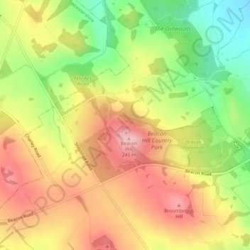
Name: Conservation Area topographic map, elevation, terrain.
Average elevation: 551 ft
Minimum elevation: 246 ft
Maximum elevation: 810 ft
Other topographic maps
Click on a map to view its topography, its elevation and its terrain.
South Croxton
United Kingdom > England > Leicestershire > Charnwood > South Croxton
The highest point is the church, at 120 m above mean sea level. The lowest altitude is 85 m by the Queniborough Brook.
Average elevation: 354 ft
Lower Moor
United Kingdom > England > Leicestershire > Charnwood > Cossington
Average elevation: 174 ft
Queniborough
United Kingdom > England > Leicestershire > Charnwood > Queniborough
Average elevation: 246 ft
Beeby
United Kingdom > England > Leicestershire > Charnwood
The physical and historical development of the hamlet has been strongly influenced by the local topography and its relative isolation. Beeby is situated within an established agricultural landscape largely in pastoral use. Until 1904 the east-west route was the only route through the hamlet, which was referred…
Average elevation: 331 ft
Barrow upon Soar
United Kingdom > England > Leicestershire > Charnwood > Barrow upon Soar
Average elevation: 203 ft
Mountsorrel
United Kingdom > England > Leicestershire > Charnwood > Mountsorrel
Average elevation: 187 ft
Charnwood Water
United Kingdom > England > Leicestershire > Charnwood > Woodthorpe
Average elevation: 154 ft
Thurmaston
United Kingdom > England > Leicestershire > Charnwood > Thurmaston
Average elevation: 203 ft
Old John
United Kingdom > England > Leicestershire > Charnwood > Newtown Linford
Average elevation: 469 ft
Six Hills
United Kingdom > England > Leicestershire > Charnwood > Burton on the Wolds
Average elevation: 420 ft
Ratcliffe on the Wreake
United Kingdom > England > Leicestershire > Charnwood
Average elevation: 226 ft
East Goscote
United Kingdom > England > Leicestershire > Charnwood > East Goscote
Average elevation: 200 ft
Barrow upon Soar
United Kingdom > England > Leicestershire > Charnwood > Barrow upon Soar
Average elevation: 203 ft
Thurmaston
United Kingdom > England > Leicestershire > Charnwood > Thurmaston
Average elevation: 203 ft
Mammoth Lake
United Kingdom > England > Leicestershire > Charnwood > Thurmaston
Average elevation: 190 ft