
Make a donation
Gear up for your next adventure:
As an Amazon Associate, this site earns from qualifying purchases at no extra cost to you.
Emmerich am Rhein topographic map
Click on the map to display elevation.
Make a donation
Gear up for your next adventure:
As an Amazon Associate, this site earns from qualifying purchases at no extra cost to you.
Emmerich am Rhein
Emmerich gehört geographisch zur Unteren Rheinniederung, einem Teil des Niederrheinischen Tieflands. Die Innenstadt liegt auf einer Höhe von 17 Metern über NN. Der tiefste Punkt des Stadtgebietes liegt im Rheinvorland mit 13 Metern. Der Eltenberg mit einer Höhenlage bis zu 82 Metern wird der naturräumlichen Haupteinheit Eltener Höhen zugeordnet.
Make a donation
Gear up for your next adventure:
As an Amazon Associate, this site earns from qualifying purchases at no extra cost to you.
About this map
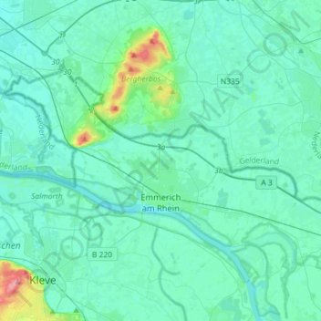
Name: Emmerich am Rhein topographic map, elevation, terrain.
Average elevation: 59 ft
Minimum elevation: 23 ft
Maximum elevation: 328 ft
Make a donation
Gear up for your next adventure:
As an Amazon Associate, this site earns from qualifying purchases at no extra cost to you.
Other topographic maps
Click on a map to view its topography, its elevation and its terrain.
Make a donation
Gear up for your next adventure:
As an Amazon Associate, this site earns from qualifying purchases at no extra cost to you.
Make a donation
Gear up for your next adventure:
As an Amazon Associate, this site earns from qualifying purchases at no extra cost to you.
Pfalzdorf
Deutschland > Nordrhein-Westfalen > Kreis Kleve > Goch
Pfalzdorf liegt links des Rheins im niederrheinischen Tiefland zwischen Goch, Kalkar und Kleve auf den Pfalzdorfer Höhen, einem Teil des Niederrheinischen Höhenzugs. Benachbarte Orte sind Bedburg-Hau im Norden, Louisendorf im Nordosten, Keppeln im Osten, Goch im Süden, Asperden im Südwesten und Nierswalde…
Average elevation: 82 ft
Make a donation
Gear up for your next adventure:
As an Amazon Associate, this site earns from qualifying purchases at no extra cost to you.
Make a donation
Gear up for your next adventure:
As an Amazon Associate, this site earns from qualifying purchases at no extra cost to you.
Make a donation
Gear up for your next adventure:
As an Amazon Associate, this site earns from qualifying purchases at no extra cost to you.
Ferienpark Kevelaer
Deutschland > Nordrhein-Westfalen > Kreis Kleve > Kevelaer > Schravelnsche Heide
Average elevation: 69 ft
Make a donation
Gear up for your next adventure:
As an Amazon Associate, this site earns from qualifying purchases at no extra cost to you.
Make a donation
Gear up for your next adventure:
As an Amazon Associate, this site earns from qualifying purchases at no extra cost to you.
Make a donation
Gear up for your next adventure:
As an Amazon Associate, this site earns from qualifying purchases at no extra cost to you.
Make a donation
Gear up for your next adventure:
As an Amazon Associate, this site earns from qualifying purchases at no extra cost to you.
Gieselberg
Deutschland > Nordrhein-Westfalen > Kreis Kleve > Straelen > Auwel > Bormig
Average elevation: 115 ft
Make a donation
Gear up for your next adventure:
As an Amazon Associate, this site earns from qualifying purchases at no extra cost to you.
Pfalzdorf
Deutschland > Nordrhein-Westfalen > Kreis Kleve > Goch
Pfalzdorf liegt links des Rheins im niederrheinischen Tiefland zwischen Goch, Kalkar und Kleve auf den Pfalzdorfer Höhen, einem Teil des Niederrheinischen Höhenzugs. Benachbarte Orte sind Bedburg-Hau im Norden, Louisendorf im Nordosten, Keppeln im Osten, Goch im Süden, Asperden im Südwesten und Nierswalde…
Average elevation: 82 ft
Make a donation
Gear up for your next adventure:
As an Amazon Associate, this site earns from qualifying purchases at no extra cost to you.