
Pelzer topographic map
Click on the map to display elevation.
About this map
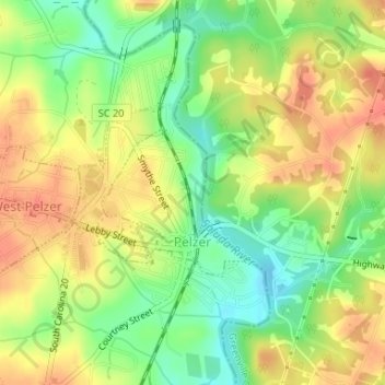
Name: Pelzer topographic map, elevation, terrain.
Location: Pelzer, Anderson County, South Carolina, United States (34.63991 -82.46634 34.65174 -82.45140)
Average elevation: 784 ft
Minimum elevation: 696 ft
Maximum elevation: 856 ft
Anderson County trails, hiking, mountain biking, running and outdoor activities
Other topographic maps
Click on a map to view its topography, its elevation and its terrain.
Sweet Gum Trail
United States > South Carolina > Anderson County > Sweet Gum Trail
Average elevation: 745 ft
Huntington Hills
United States > South Carolina > Anderson County > Huntington Hills
Average elevation: 774 ft
Pendleton Gardens
United States > South Carolina > Anderson County > Pendleton
Average elevation: 787 ft
Caldwell Village
United States > South Carolina > Anderson County > Anderson
Average elevation: 758 ft