Geolocate

Center Point topographic map

Click on the map to display elevation.

About this map

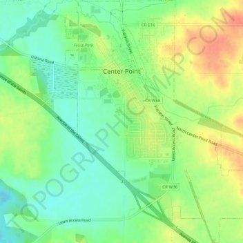
Name: Center Point topographic map, elevation, terrain.

Location: Center Point, Linn County, Iowa, 52213, United States (42.16500 -91.79669 42.20149 -91.76032)

Average elevation: 817 ft

Minimum elevation: 745 ft

Maximum elevation: 906 ft

Linn County trails, hiking, mountain biking, running and outdoor activities

Other topographic maps

Click on a map to view its topography, its elevation and its terrain.

Cedar Rapids

United States > Iowa > Linn County > Cedar Rapids

Average elevation: 817 ft

Central City

United States > Iowa > Linn County > Central City

Average elevation: 883 ft

Toddville

United States > Iowa > Linn County

Average elevation: 833 ft

Bertram

United States > Iowa > Linn County > Bertram > Bertram

Average elevation: 758 ft

Gear up for your next adventure:

🧯Emergency Survival Kit - All‑in‑one survival essentials for the backcountry
🔊Portable Camp Speaker - Music and alerts at camp
🔭Stargazing Telescopes - Perfect for camping in low-light pollution areas shown on maps
🥘Titanium Cookware - Durable, featherlight pots and pans for backpacking
🥤Water Filter Bottle - All‑in‑one filter bottle for safe hydration

As an Amazon Associate, this site earns from qualifying purchases at no extra cost to you.