
Make a donation
Gear up for your next adventure:
As an Amazon Associate, this site earns from qualifying purchases at no extra cost to you.
Valiyathovala topographic map
Click on the map to display elevation.
Make a donation
Gear up for your next adventure:
As an Amazon Associate, this site earns from qualifying purchases at no extra cost to you.
About this map
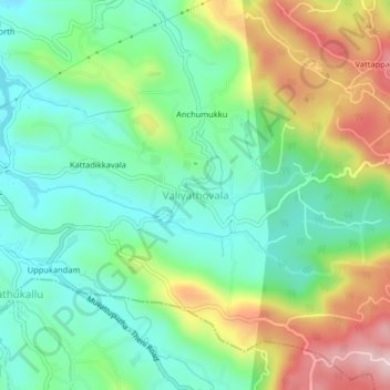
Name: Valiyathovala topographic map, elevation, terrain.
Location: Valiyathovala, Udumbanchola, Idukki, Kerala, 685514, India (9.77631 77.10679 9.81631 77.14679)
Average elevation: 2,828 ft
Minimum elevation: 2,405 ft
Maximum elevation: 3,645 ft
Make a donation
Gear up for your next adventure:
As an Amazon Associate, this site earns from qualifying purchases at no extra cost to you.
Other topographic maps
Click on a map to view its topography, its elevation and its terrain.
Chempakapara
India > Kerala > Udumbanchola > Chempakappara > Kochukamakshy
Average elevation: 2,661 ft
Make a donation
Gear up for your next adventure:
As an Amazon Associate, this site earns from qualifying purchases at no extra cost to you.
Make a donation
Gear up for your next adventure:
As an Amazon Associate, this site earns from qualifying purchases at no extra cost to you.