
Rigaud topographic map
Click on the map to display elevation.
About this map
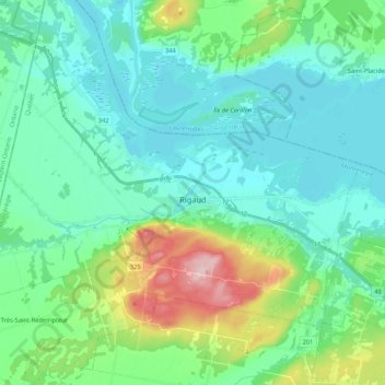
Name: Rigaud topographic map, elevation, terrain.
Average elevation: 203 ft
Minimum elevation: 56 ft
Maximum elevation: 748 ft
Other topographic maps
Click on a map to view its topography, its elevation and its terrain.
Saint-Lazare
Canada > Quebec > Vaudreuil-Soulanges > Saint-Lazare > Saint-Lazare
Average elevation: 210 ft
Domaine du Lac
Canada > Quebec > Vaudreuil-Soulanges > Notre-Dame-de-l'Île-Perrot
Average elevation: 89 ft