Geolocate

Lachute topographic map

Click on the map to display elevation.

About this map

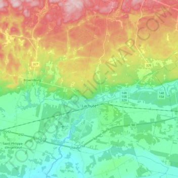
Name: Lachute topographic map, elevation, terrain.

Location: Lachute, Argenteuil, Laurentides, Quebec, Canada (45.59900 -74.37927 45.73962 -74.20395)

Average elevation: 417 ft

Minimum elevation: 105 ft

Maximum elevation: 978 ft

Other topographic maps

Click on a map to view its topography, its elevation and its terrain.

Lac MacLeod

Canada > Quebec > Argenteuil > Harrington

Average elevation: 951 ft

Lac Fiddler

Canada > Quebec > Argenteuil > Mille-Isles

Average elevation: 1,148 ft

Lac Bixley

Canada > Quebec > Argenteuil > Wentworth

Average elevation: 971 ft

Lac Beattie

Canada > Quebec > Argenteuil > Gore

Average elevation: 745 ft

Calumet

Canada > Quebec > Argenteuil > Grenville-sur-la-Rouge

Average elevation: 312 ft

Lac Crooks

Canada > Quebec > Argenteuil > Brownsburg-Chatham

Average elevation: 673 ft

Lac Robinson

Canada > Quebec > Argenteuil > Grenville-sur-la-Rouge

Average elevation: 623 ft

Lakefield

Canada > Quebec > Argenteuil > Gore > Lakefield

Average elevation: 863 ft

Lac Mikiwam

Canada > Quebec > Argenteuil > Harrington

Average elevation: 925 ft

Marelan

Canada > Quebec > Argenteuil > Grenville-sur-la-Rouge

Average elevation: 279 ft

Lac Dainava

Canada > Quebec > Argenteuil > Mille-Isles

Average elevation: 1,017 ft

Gear up for your next adventure:

🧭Compass with Lanyard - Easy‑carry compass for navigation
👖Convertible Hiking Pants - Versatile zip-off pants for changing altitudes and temperatures
🎒Trekking Poles - Sturdy poles for balance and stability on rough terrain
🧭Map Reading Tools - Tools and kits for map navigation
🌡️Portable Weather Meter - Track weather conditions on the trail

As an Amazon Associate, this site earns from qualifying purchases at no extra cost to you.