Geolocate

Hays topographic map

Click on the map to display elevation.

About this map

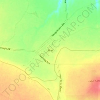
Name: Hays topographic map, elevation, terrain.

Location: Hays, Division No. 2, Alberta, Canada (50.07718 -111.81501 50.11718 -111.77501)

Average elevation: 2,562 ft

Minimum elevation: 2,451 ft

Maximum elevation: 2,664 ft

Gear up for your next adventure:

🪓Survival Multi‑Tool - Versatile tool for camp and trail tasks
📱Heavy-Duty Phone Cases - Drop-proof and waterproof protection for outdoor navigation
🧣Merino Neck Gaiters - Multi-functional headwear for wind and sun protection
🛡️Insect Repellent - Protection against bugs during outdoor activities
🧯Emergency Survival Kit - All‑in‑one survival essentials for the backcountry

As an Amazon Associate, this site earns from qualifying purchases at no extra cost to you.