
Weyburn topographic map
Interactive map
Click on the map to display elevation.
About this map
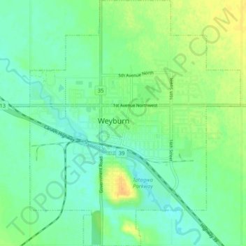
Name: Weyburn topographic map, elevation, terrain.
Location: Weyburn, Census Division No. 2, Saskatchewan, Canada (49.63909 -103.88636 49.69009 -103.81317)
Average elevation: 1,873 ft
Minimum elevation: 1,841 ft
Maximum elevation: 1,926 ft
Other topographic maps
Click on a map to view its topography, its elevation and its terrain.
Weyburn
Canada > Saskatchewan > Weyburn
Weyburn, Saskatchewan, S4H 2J4, Canada
Average elevation: 1,919 ft