
Make a donation
Gear up for your next adventure:
As an Amazon Associate, this site earns from qualifying purchases at no extra cost to you.
Soccsksargen topographic map
Click on the map to display elevation.
Make a donation
Gear up for your next adventure:
As an Amazon Associate, this site earns from qualifying purchases at no extra cost to you.
About this map
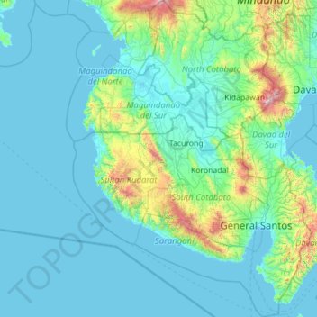
Name: Soccsksargen topographic map, elevation, terrain.
Location: Soccsksargen, Philippines (5.47000 123.88164 7.68566 125.55828)
Average elevation: 725 ft
Minimum elevation: -3 ft
Maximum elevation: 9,426 ft
Make a donation
Gear up for your next adventure:
As an Amazon Associate, this site earns from qualifying purchases at no extra cost to you.
Other topographic maps
Click on a map to view its topography, its elevation and its terrain.
Dinagsaan Peak
Philippines > Davao Oriental > Banaybanay > Pintatagan > Looc
Average elevation: 951 ft
Make a donation
Gear up for your next adventure:
As an Amazon Associate, this site earns from qualifying purchases at no extra cost to you.
Make a donation
Gear up for your next adventure:
As an Amazon Associate, this site earns from qualifying purchases at no extra cost to you.
Make a donation
Gear up for your next adventure:
As an Amazon Associate, this site earns from qualifying purchases at no extra cost to you.
Santa
Philippines > Ilocos Sur > Santa
The topography of the municipality is undulating to rolling with slope ranging from 0-30%.
Average elevation: 246 ft