
Thank you for supporting this site ❤️
Make a donation
Make a donation
Gear up for your next adventure:
As an Amazon Associate, this site earns from qualifying purchases at no extra cost to you.
Graswang topographic map
Click on the map to display elevation.
Thank you for supporting this site ❤️
Make a donation
Make a donation
Gear up for your next adventure:
As an Amazon Associate, this site earns from qualifying purchases at no extra cost to you.
About this map
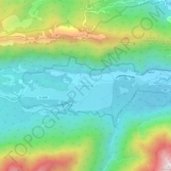
Name: Graswang topographic map, elevation, terrain.
Average elevation: 3,740 ft
Minimum elevation: 2,769 ft
Maximum elevation: 6,158 ft
Thank you for supporting this site ❤️
Make a donation
Make a donation
Gear up for your next adventure:
As an Amazon Associate, this site earns from qualifying purchases at no extra cost to you.
Other topographic maps
Click on a map to view its topography, its elevation and its terrain.
Soiernsee
Germany > Bavaria > Landkreis Garmisch-Partenkirchen > Mittenwald
Average elevation: 5,794 ft
Staffelsee
Germany > Bavaria > Landkreis Garmisch-Partenkirchen > Seehausen am Staffelsee
Average elevation: 2,169 ft