
Lake of the Woods topographic map
Interactive map
Click on the map to display elevation.
Lake of the Woods
Lake of the Woods is located near the crest of the Cascade Mountains in western Klamath County, Oregon. Its elevation is 4,949 feet (1,508 m) above sea level. The lake is surrounded by the Fremont–Winema National Forest. Lake of the Woods is 33 miles (53 km) west of Klamath Falls and 43 miles (69 km) east of Medford. The small unincorporated community of Lake of the Woods, Oregon, is located on the east shore of the lake, approximately 1⁄2 mile (0.80 km) south of Oregon Route 140. There is a Forest Service visitor center at the historic Lake of the Woods Ranger Station at the north end of the lake, just off Route 140. The visitor center is open during the summer.
About this map
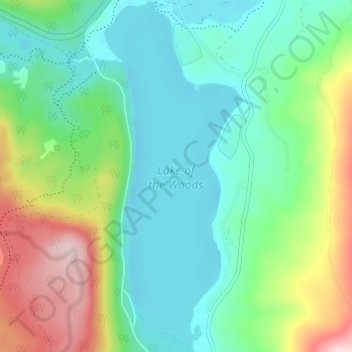
Name: Lake of the Woods topographic map, elevation, terrain.
Location: Lake of the Woods, Klamath County, Oregon, United States (42.34352 -122.22695 42.38850 -122.20306)
Average elevation: 5,210 ft
Minimum elevation: 4,925 ft
Maximum elevation: 5,899 ft
Klamath County trails, hiking, mountain biking, running and outdoor activities
Other topographic maps
Click on a map to view its topography, its elevation and its terrain.
Klamath Falls
United States > Oregon > Klamath County
Klamath Falls, located at an elevation of approximately 4,108 feet, is situated in a striking topographical region characterized by a mix of mountainous terrains and expansive lakes. The city is bordered by the Klamath Mountains to the west, which feature rugged, volcanic formations and steep slopes that…
Average elevation: 4,304 ft
Crater Lake National Park
United States > Oregon > Klamath County
The caldera rim ranges in elevation from 7,000 to 8,000 feet (2,100 to 2,400 m). The United States Geological Survey benchmark elevation of the lake surface is 6,178 feet (1,883 m). The national park encompasses 183,224 acres (286.3 sq mi; 741.5 km2). Crater Lake has no streams flowing into or out of it. All…
Average elevation: 5,663 ft
Sky Lakes Wilderness
United States > Oregon > Klamath County
The Sky Lakes Wilderness straddles southern Oregon's Cascade Range from Crater Lake National Park southward to Oregon Route 140. It is approximately 6 miles (9.7 km) wide and 27 miles (43 km) long, with elevations ranging from 3,800 feet (1,200 m) in the canyon of the Middle Fork of the Rogue River to 9,495…
Average elevation: 4,688 ft
Crater Lake
United States > Oregon > Klamath County
The lake is 5 by 6 miles (8.0 by 9.7 km) across, with a caldera rim ranging in elevation from 7,000 to 8,000 feet (2,100 to 2,400 m) and an average lake depth of 1,148 feet (350 m). The lake's maximum depth has been measured at 1,949 feet (594 m), which fluctuates slightly as the weather changes. On the basis…
Average elevation: 6,467 ft
Bonanza
United States > Oregon > Klamath County
Bonanza is at an elevation of 4,127 feet (1,258 m) in southern Klamath County near the Oregon–California border. The town is at the east end of Oregon Route 70, a spur off Oregon Route 140. By highway, Bonanza is about 21 miles (34 km) from Klamath Falls and 300 miles (483 km) from Portland.
Average elevation: 4,144 ft
Mount Scott
United States > Oregon > Klamath County
There is one trail to the summit of Mount Scott. Starting on Rim Drive, the trail is about 2.5 miles (4.0 km) long. It has many switchbacks, and ends at the fire lookout tower on the summit. The trailhead is at an elevation of 7,683 feet (2,342 m), and the trail climbs approximately 1,479 feet (451 m) to the…
Average elevation: 7,530 ft
Chiloquin
United States > Oregon > Klamath County
Chiloquin is at an elevation of 4,180 feet (1,270 m) in Klamath County. The city is slightly east of U.S. Route 97 and slightly north of its intersection with Oregon Route 62. A short east–west highway, Oregon Route 422, links Route 97 at Chiloquin to Route 62 slightly south of Klamath Agency. By highway,…
Average elevation: 4,272 ft
Crater Lake
United States > Oregon > Klamath County
The lake is 5 by 6 miles (8.0 by 9.7 km) across, with a caldera rim ranging in elevation from 7,000 to 8,000 feet (2,100 to 2,400 m) and an average lake depth of 1,148 feet (350 m). The lake's maximum depth has been measured at 1,949 feet (594 m), which fluctuates slightly as the weather changes. On the basis…
Average elevation: 6,467 ft
Klamath Falls
United States > Oregon > Klamath County
According to the United States Census Bureau, the city has a total area of 20.66 square miles (53.51 km2), of which 19.81 square miles (51.31 km2) is land and 0.85 square miles (2.20 km2) is water. The elevation is 4,094 feet (1,248 m).
Average elevation: 4,304 ft
Crater Lake
United States > Oregon > Klamath County
The lake is 5 by 6 miles (8.0 by 9.7 km) across, with a caldera rim ranging in elevation from 7,000 to 8,000 feet (2,100 to 2,400 m) and an average lake depth of 1,148 feet (350 m). The lake's maximum depth has been measured at 1,949 feet (594 m), which fluctuates slightly as the weather changes. On the basis…
Average elevation: 6,467 ft
Crater Lake National Park
United States > Oregon > Klamath County
The caldera rim ranges in elevation from 7,000 to 8,000 feet (2,100 to 2,400 m). The United States Geological Survey benchmark elevation of the lake surface is 6,178 feet (1,883 m). The national park encompasses 183,224 acres (286.3 sq mi; 741.5 km2). Crater Lake has no streams flowing into or out of it. All…
Average elevation: 5,663 ft
Chiloquin
United States > Oregon > Klamath County
Chiloquin is at an elevation of 4,180 feet (1,270 m) in Klamath County. The city is slightly east of U.S. Route 97 and slightly north of its intersection with Oregon Route 62. A short east–west highway, Oregon Route 422, links Route 97 at Chiloquin to Route 62 slightly south of Klamath Agency. By highway,…
Average elevation: 4,272 ft