
Make a donation
Gear up for your next adventure:
As an Amazon Associate, this site earns from qualifying purchases at no extra cost to you.
Birgitz topographic map
Click on the map to display elevation.
Make a donation
Gear up for your next adventure:
As an Amazon Associate, this site earns from qualifying purchases at no extra cost to you.
About this map
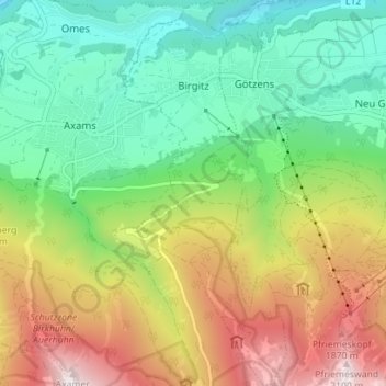
Name: Birgitz topographic map, elevation, terrain.
Location: Birgitz, Bezirk Innsbruck-Land, Tyrol, 6092, Autriche (47.19861 11.28572 47.24621 11.31694)
Average elevation: 3,963 ft
Minimum elevation: 2,182 ft
Maximum elevation: 6,919 ft
Make a donation
Gear up for your next adventure:
As an Amazon Associate, this site earns from qualifying purchases at no extra cost to you.
Other topographic maps
Click on a map to view its topography, its elevation and its terrain.
Serles
Autriche > Tyrol > Bezirk Innsbruck-Land > Fulpmes
Le Serles (aussi appelé Waldrastspitze) est une montagne culminant à 2 717 m d'altitude dans les Alpes de Stubai.
Average elevation: 6,680 ft
Make a donation
Gear up for your next adventure:
As an Amazon Associate, this site earns from qualifying purchases at no extra cost to you.
Nördliche Kräulspitze
Autriche > Tyrol > Bezirk Innsbruck-Land > Neustift im Stubaital
Average elevation: 9,370 ft
Make a donation
Gear up for your next adventure:
As an Amazon Associate, this site earns from qualifying purchases at no extra cost to you.