Geolocate

Spencerville topographic map

Click on the map to display elevation.

About this map

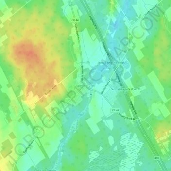
Name: Spencerville topographic map, elevation, terrain.

Location: Spencerville, Edwardsburgh/Cardinal, Leeds and Grenville Counties, Eastern Ontario, Ontario, Canada (44.82330 -75.56637 44.86330 -75.52637)

Average elevation: 325 ft

Minimum elevation: 272 ft

Maximum elevation: 400 ft

Other topographic maps

Click on a map to view its topography, its elevation and its terrain.

Gear up for your next adventure:

👓Polarized Sunglasses - Outdoor sunglasses for glare reduction
🏕️Tent Footprint - Protect your tent base from wear
🧭Outdoor Navigation Book - Learn advanced navigation skills
🦶Carbon Trekking Poles - Reduce knee impact on steep descents with ultra-light poles
📻Weather Alert Radios - Stay informed of storm risks while off-the-grid

As an Amazon Associate, this site earns from qualifying purchases at no extra cost to you.