
Make a donation
Gear up for your next adventure:
As an Amazon Associate, this site earns from qualifying purchases at no extra cost to you.
Milmersdorf topographic map
Click on the map to display elevation.
Make a donation
Gear up for your next adventure:
As an Amazon Associate, this site earns from qualifying purchases at no extra cost to you.
Milmersdorf
Die uckermärkische Gemeinde liegt in einem wald- und seenreichen Gebiet zwischen den Städten Prenzlau, Joachimsthal und Templin. Das Gemeindegebiet reicht im Süden bis in die Schorfheide und hat Anteile am Biosphärenreservat Schorfheide-Chorin. Die hügelige Umgebung erreicht nahe dem Ortsteil Hohenwalde eine Höhe von 109 m ü. NHN. Der größte See im Gemeindegebiet ist der Kölpinsee.
Make a donation
Gear up for your next adventure:
As an Amazon Associate, this site earns from qualifying purchases at no extra cost to you.
About this map
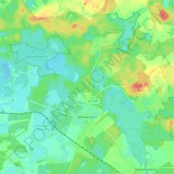
Name: Milmersdorf topographic map, elevation, terrain.
Location: Milmersdorf, Gerswalde, Uckermark, Brandenburg, Deutschland (53.09461 13.57314 53.14617 13.67397)
Average elevation: 213 ft
Minimum elevation: 161 ft
Maximum elevation: 325 ft
Make a donation
Gear up for your next adventure:
As an Amazon Associate, this site earns from qualifying purchases at no extra cost to you.
Other topographic maps
Click on a map to view its topography, its elevation and its terrain.
Make a donation
Gear up for your next adventure:
As an Amazon Associate, this site earns from qualifying purchases at no extra cost to you.
Make a donation
Gear up for your next adventure:
As an Amazon Associate, this site earns from qualifying purchases at no extra cost to you.
Make a donation
Gear up for your next adventure:
As an Amazon Associate, this site earns from qualifying purchases at no extra cost to you.
Cremzow
Deutschland > Brandenburg > Uckermark > Carmzow
Cremzow liegt an der Landesstraße 252 zwischen Kleptow und Weselitz. Die Bundesautobahn 20 mit der Anschlussstelle Prenzlau-Ost ist etwa fünf Kilometer entfernt. Cremzow liegt am Ufer des Großen Sees, östlich des Ortes befindet sich zudem der Höhenzug Rehberge mit einer Höhe von bis zu 66 m ü. NHN.
Average elevation: 167 ft
Make a donation
Gear up for your next adventure:
As an Amazon Associate, this site earns from qualifying purchases at no extra cost to you.
Das große rote Meer
Deutschland > Brandenburg > Uckermark > Sternhagen > Hof Sternhagen
Average elevation: 141 ft
Make a donation
Gear up for your next adventure:
As an Amazon Associate, this site earns from qualifying purchases at no extra cost to you.
Make a donation
Gear up for your next adventure:
As an Amazon Associate, this site earns from qualifying purchases at no extra cost to you.
Make a donation
Gear up for your next adventure:
As an Amazon Associate, this site earns from qualifying purchases at no extra cost to you.