
Make a donation
Gear up for your next adventure:
As an Amazon Associate, this site earns from qualifying purchases at no extra cost to you.
Pleasant Garden topographic map
Click on the map to display elevation.
Make a donation
Gear up for your next adventure:
As an Amazon Associate, this site earns from qualifying purchases at no extra cost to you.
About this map
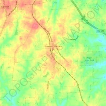
Name: Pleasant Garden topographic map, elevation, terrain.
Average elevation: 794 ft
Minimum elevation: 686 ft
Maximum elevation: 902 ft
Guilford County trails, hiking, mountain biking, running and outdoor activities
Make a donation
Gear up for your next adventure:
As an Amazon Associate, this site earns from qualifying purchases at no extra cost to you.
Other topographic maps
Click on a map to view its topography, its elevation and its terrain.
Make a donation
Gear up for your next adventure:
As an Amazon Associate, this site earns from qualifying purchases at no extra cost to you.
Piedmont Heights
United States > North Carolina > Guilford County > Greensboro
Average elevation: 823 ft
Hamilton Lakes
United States > North Carolina > Guilford County > Greensboro
Average elevation: 866 ft
Make a donation
Gear up for your next adventure:
As an Amazon Associate, this site earns from qualifying purchases at no extra cost to you.
Sherwood Village
United States > North Carolina > Guilford County > High Point
Average elevation: 860 ft
Make a donation
Gear up for your next adventure:
As an Amazon Associate, this site earns from qualifying purchases at no extra cost to you.
Hamilton Hills
United States > North Carolina > Guilford County > Greensboro
Average elevation: 899 ft
Make a donation
Gear up for your next adventure:
As an Amazon Associate, this site earns from qualifying purchases at no extra cost to you.
Melborne Heights
United States > North Carolina > Guilford County > High Point
Average elevation: 840 ft
Make a donation
Gear up for your next adventure:
As an Amazon Associate, this site earns from qualifying purchases at no extra cost to you.
Horsepen Creek
United States > North Carolina > Guilford County > Greensboro
Average elevation: 817 ft