
Thank you for supporting this site ❤️
Make a donation
Make a donation
Gear up for your next adventure:
As an Amazon Associate, this site earns from qualifying purchases at no extra cost to you.
Chalinga topographic map
Click on the map to display elevation.
Thank you for supporting this site ❤️
Make a donation
Make a donation
Gear up for your next adventure:
As an Amazon Associate, this site earns from qualifying purchases at no extra cost to you.
About this map
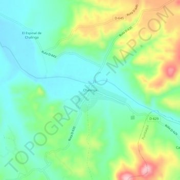
Name: Chalinga topographic map, elevation, terrain.
Average elevation: 548 ft
Minimum elevation: 344 ft
Maximum elevation: 974 ft
Thank you for supporting this site ❤️
Make a donation
Make a donation
Gear up for your next adventure:
As an Amazon Associate, this site earns from qualifying purchases at no extra cost to you.
Other topographic maps
Click on a map to view its topography, its elevation and its terrain.
Embalse Recoleta
Chile > Región de Coquimbo > Provincia de Limarí > Ovalle
Average elevation: 1,716 ft
Parque Nacional Bosque de Fray Jorge
Chile > Región de Coquimbo > Provincia de Limarí > Ovalle
Average elevation: 564 ft