
Make a donation
Gear up for your next adventure:
As an Amazon Associate, this site earns from qualifying purchases at no extra cost to you.
Embalse Recoleta topographic map
Click on the map to display elevation.
Make a donation
Gear up for your next adventure:
As an Amazon Associate, this site earns from qualifying purchases at no extra cost to you.
About this map
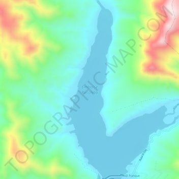
Name: Embalse Recoleta topographic map, elevation, terrain.
Average elevation: 1,716 ft
Minimum elevation: 1,240 ft
Maximum elevation: 3,120 ft
Make a donation
Gear up for your next adventure:
As an Amazon Associate, this site earns from qualifying purchases at no extra cost to you.
Other topographic maps
Click on a map to view its topography, its elevation and its terrain.
Cerrillos de Tamaya
Chile > Región de Coquimbo > Provincia de Limarí > Ovalle
Average elevation: 840 ft
Parque Nacional Bosque de Fray Jorge
Chile > Región de Coquimbo > Provincia de Limarí > Ovalle
Average elevation: 564 ft
Make a donation
Gear up for your next adventure:
As an Amazon Associate, this site earns from qualifying purchases at no extra cost to you.
Potrerillos Altos
Chile > Región de Coquimbo > Provincia de Limarí > Ovalle > Nueva Aurora > Potrerillos Altos
Average elevation: 1,112 ft
Make a donation
Gear up for your next adventure:
As an Amazon Associate, this site earns from qualifying purchases at no extra cost to you.
La Cebada
Chile > Región de Coquimbo > Provincia de Limarí > Ovalle > La Cebada
Average elevation: 276 ft