Geolocate

Nashik topographic map

Click on the map to display elevation.

About this map

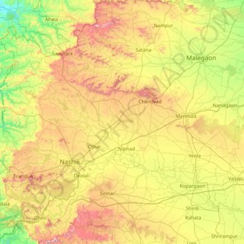
Name: Nashik topographic map, elevation, terrain.

Location: Nashik, Maharashtra, India (19.51667 73.38333 20.91667 74.78333)

Average elevation: 1,821 ft

Minimum elevation: 236 ft

Maximum elevation: 5,125 ft

Other topographic maps

Click on a map to view its topography, its elevation and its terrain.

Mumbai

India > Maharashtra > Mumbai

Mumbai is on a narrow peninsula on the southwest of Salsette Island, which lies between the Arabian Sea to the west, Thane Creek to the east and Vasai Creek to the north. Mumbai's suburban district occupies most of the island. Navi Mumbai is east of Thane Creek and Thane is north of Vasai Creek. Mumbai…

Average elevation: 59 ft

Mumbai

India > Maharashtra

Mumbai is on a narrow peninsula on the southwest of Salsette Island, which lies between the Arabian Sea to the west, Thane Creek to the east and Vasai Creek to the north. Mumbai's suburban district occupies most of the island. Navi Mumbai is east of Thane Creek and Thane is north of Vasai Creek. Mumbai…

Average elevation: 59 ft

Pune City

India > Maharashtra

Pune lies on the western margin of the Deccan plateau, at an altitude of 560 m (1,840 ft) above sea level. It is on the leeward side of the Sahyadri mountain range, which forms a barrier from the Arabian Sea. It is a hilly city, with Vetal Hill rising to 800 m (2,600 ft) above sea level. The Sinhagad fort is…

Average elevation: 2,021 ft

Dindori Taluka

India > Maharashtra

Average elevation: 2,201 ft

Raigad

India > Maharashtra

Average elevation: 778 ft

Nanded District

India > Maharashtra

Nanded is bounded on the north by Yavatmal district of the Vidarbha region, with Latur on south-west, Parbhani and Hingoli districts on the west. On the eastern side lies Adilabad, Nirmal, Nizamabad and Kamareddy districts of Telangana state, and on the south lies Bidar of Karnataka state. The area presents…

Average elevation: 1,417 ft

Latur District

India > Maharashtra

Latur district is in the Marathwada region in Maharashtra in India, located between 17°52' North to 18°50' North and 76°18' East to 79°12' East in the Deccan plateau. It has an average elevation of 631 metres (2,070 ft) above mean sea level. The entire district of Latur is on the Balaghat plateau, 540 to…

Average elevation: 1,936 ft

Pune District

India > Maharashtra

Average elevation: 1,709 ft

Shevgaon

India > Maharashtra

Average elevation: 1,617 ft

Satara

India > Maharashtra

Average elevation: 2,221 ft

Mumbai

India > Maharashtra

Average elevation: 82 ft

Pune

India > Maharashtra

Pune is situated at approximately 18° 32" north latitude and 73° 51" east longitude. The city's total area is 15.642 km2, and the municipal corporation area covers 518 km2. By road Pune is 149 km (93 mi) south-east of Mumbai, 580 km (360 mi) south-west of Indore, 695 km (432 mi) west of Nagpur, 1,173 km (729…

Average elevation: 2,021 ft

Niphad Taluka

India > Maharashtra

Average elevation: 1,919 ft

Solapur District

India > Maharashtra

Average elevation: 1,854 ft

Paithan

India > Maharashtra

Paithan is located at 19°29′N 75°23′E / 19.48°N 75.38°E / 19.48; 75.38. It has an average elevation of 458 m (1,503 ft).

Average elevation: 1,624 ft

Hatkanangle

India > Maharashtra

Average elevation: 1,883 ft

Aundha (Nagnath)

India > Maharashtra

Average elevation: 1,460 ft

Akrani Taluka

India > Maharashtra

Average elevation: 1,398 ft

Rahuri

India > Maharashtra

Average elevation: 1,847 ft

Ahmednagar District

India > Maharashtra

Average elevation: 1,955 ft

Ratnagiri

India > Maharashtra

An outstanding feature of the geography of the district is its uneven or hill topography, with about 45% of the district being characterized as 'hilly'. Very narrow riverine plains fringe the coastline.

Average elevation: 988 ft

Haveli

India > Maharashtra

Average elevation: 2,116 ft

Yavatmal District

India > Maharashtra

Average elevation: 1,076 ft

Wardha

India > Maharashtra

Average elevation: 1,027 ft

Ambegaon

India > Maharashtra

Average elevation: 2,306 ft

Jalgaon District

India > Maharashtra

Average elevation: 1,309 ft

Panhala

India > Maharashtra

Panhala is located at 16°49′12″N 74°7′12″E / 16.82000°N 74.12000°E / 16.82000; 74.12000. It has an average elevation of 754 metres (2473 feet). Panhala is connected via train and bus to Kolhapur and Sangli. Kolhapur is about 21 km away while Sangli is about 60 km. Kolhapur Chhatrapati…

Average elevation: 2,034 ft

Shahuwadi

India > Maharashtra

Average elevation: 1,972 ft

Shahapur Taluka

India > Maharashtra

Average elevation: 735 ft

Mangrulpir

India > Maharashtra

Average elevation: 1,519 ft

Lonar

India > Maharashtra

Average elevation: 1,775 ft

Washim

India > Maharashtra

Average elevation: 1,355 ft

Bhor

India > Maharashtra

Average elevation: 2,503 ft

Nashik District

India > Maharashtra

The entire Nashik district is underlain by the basaltic lava flows. These flows are normally horizontally disposed over a wide stretch and give rise to table land type of topography also known as a plateau. These flows occur in layered sequences and represented by massive unit at the bottom and vesicular unit…

Average elevation: 1,713 ft

Bramhapuri Town

India > Maharashtra > Brahmapuri Taluka

Bramhapuri is one of the six divisions located in the northeastern part of Chandrapur district, Maharashtra at 20°22′N 79°31′E / 20.36°N 79.51°E / 20.36; 79.51 and has an average elevation of 229.5 metres (753 feet). The town is located in the 73rd Vidhan Sabha constituency in Maharashtra.

Average elevation: 741 ft

Navi Mumbai

India > Maharashtra > Thane Subdistrict

Navi Mumbai (Marathi pronunciation: [nəʋiː mumbəiː]), is a planned city situated on the west coast of the Indian subcontinent, located in the Konkan division of Maharashtra state, on the mainland of India. Navi Mumbai is part of the Mumbai Metropolitan Region (MMR). The city is divided into two, North…

Average elevation: 72 ft

Chopda

India > Maharashtra

Average elevation: 1,004 ft

Shirol

India > Maharashtra

Average elevation: 1,821 ft

Akkalkot

India > Maharashtra

Average elevation: 1,568 ft

Thane

India > Maharashtra > Thane Taluka

Average elevation: 177 ft

Ghatkopar Hill

India > Maharashtra > Mumbai

Average elevation: 164 ft

Mula-Mutha River

India > Maharashtra > Pune > Khadki

Average elevation: 1,824 ft

Kolhapur District

India > Maharashtra

Kolhapur experiences winter from November to February. The winter temperatures are warmer than other cities in Maharashtra such as Pune and Nashik. Lows range from 9 to 16 °C (48 to 61 °F) while highs are in the range of 24 to 32 °C (75 to 90 °F) due to its high elevation and being adjacent to the Western…

Average elevation: 1,522 ft

Chikhaldara

India > Maharashtra

The sole hill resort in the Vidarbha region, it is situated at an altitude of 1118 meters with highest elevation point 1188 meters and has the added dimension of being the only coffee-growing area in Maharashtra. Chikhaldara has an annual rainfall of 154cm. Temperatures vary from 39C in summer to 5C in winter.…

Average elevation: 1,709 ft

Akkalkuwa Taluka

India > Maharashtra

Average elevation: 1,289 ft

Ambejogai

India > Maharashtra

Average elevation: 1,982 ft

Sentosa Water Park

India > Maharashtra > Haveli > Ravet

Average elevation: 1,893 ft

Jamgaon

India > Maharashtra > Mehkar > Mehkar

Average elevation: 1,824 ft

Sangola

India > Maharashtra > Patur > Sangola

Average elevation: 1,017 ft

M/E Ward

India > Maharashtra > Mumbai

Average elevation: 49 ft

Khidki

India > Maharashtra > Dharni

Average elevation: 1,398 ft

Pohi

India > Maharashtra > Achalpur > Achalpur

Average elevation: 1,152 ft

KANHER

India > Maharashtra > Satara > Satara

Average elevation: 2,251 ft

Kondvil Beach

India > Maharashtra > Shrivardhan Taluka

Average elevation: 52 ft

Powai Naka

India > Maharashtra > Satara > Satara

Average elevation: 2,270 ft

Waki Dam

India > Maharashtra > Baramati

Average elevation: 1,909 ft

Mohadi Town

India > Maharashtra > Mohadi Taluka

Average elevation: 853 ft

Buldhana District

India > Maharashtra

Lonarkar Top (about 923 meters) is highest altitude in Buldhana District placed in Ambabarwa Wildlife Sanctuary.

Average elevation: 1,394 ft

Pune City

India > Maharashtra

Pune lies on the western margin of the Deccan plateau, at an altitude of 560 m (1,840 ft) above sea level. It is on the leeward side of the Sahyadri mountain range, which forms a barrier from the Arabian Sea. It is a hilly city, with Vetal Hill rising to 800 m (2,600 ft) above sea level. The Sinhagad fort is…

Average elevation: 2,021 ft

Purandhar

India > Maharashtra

Average elevation: 2,277 ft

Borgaon Manju

India > Maharashtra > Akola

Average elevation: 968 ft

Usara

India > Maharashtra > Mohadi Taluka

Average elevation: 922 ft

Chitri

India > Maharashtra > Dharni

Average elevation: 1,391 ft

Korlai Fort

India > Maharashtra > Murud Taluka > Korlai

Average elevation: 7 ft

Malur

India > Maharashtra > Dharni

Average elevation: 1,250 ft

Naldurg Fort

India > Maharashtra > Tuljapur > Naldurg

Average elevation: 1,831 ft

Shevgedang

India > Maharashtra > Igatpuri Taluka

Average elevation: 2,054 ft

Shedgewadi

India > Maharashtra > Man

Average elevation: 2,959 ft

Tuljapur

India > Maharashtra > Bhatkuli

Average elevation: 1,033 ft

Banda

India > Maharashtra > Lonar

Average elevation: 1,841 ft

Shahapur

India > Maharashtra > Bhandara Taluka

Average elevation: 830 ft

Paraswada

India > Maharashtra > Tumsar Taluka > Paraswada

Average elevation: 892 ft

Shahapur

India > Maharashtra > Amravati

Average elevation: 1,276 ft

Ambernath

India > Maharashtra > Ulhasnagar Subdistrict

Average elevation: 180 ft

Bhiwandi Subdistrict

India > Maharashtra

Average elevation: 197 ft

Amravati

India > Maharashtra

Average elevation: 1,417 ft

Bahula

India > Maharashtra > Pachora > Veruli Bk

Average elevation: 830 ft

Gadchiroli

India > Maharashtra

Average elevation: 971 ft

Palghar

India > Maharashtra

Average elevation: 525 ft

Dharavi

India > Maharashtra > Mumbai

Average elevation: 20 ft

Mutha

India > Maharashtra > Haveli > Sangrun

Average elevation: 2,201 ft

Raini (R)

India > Maharashtra > Bhandara Taluka

Average elevation: 873 ft

Pandharabodi

India > Maharashtra > Bhandara Taluka > Pandharabodi

Average elevation: 856 ft

Chandrapur

India > Maharashtra

Average elevation: 755 ft

Nagpur

India > Maharashtra > Nagpur Urban Taluka

Average elevation: 1,007 ft

Khatav

India > Maharashtra

Average elevation: 2,484 ft

Chandurbazar

India > Maharashtra

Average elevation: 1,293 ft

Shivaji Park

India > Maharashtra > Mumbai

Average elevation: 23 ft

Babhulgaon

India > Maharashtra > Akola > Babhulgaon

Average elevation: 965 ft

Taroda

India > Maharashtra > Dhamangaon Railway > Taroda

Average elevation: 1,037 ft

Patalganga

India > Maharashtra > Khalapur Taluka > Jambrung

Average elevation: 312 ft

Kagal

India > Maharashtra

Kagal is a taluka in Kolhapur district. It is located at the boundary of Maharashtra and Karnataka. The Chhatrapati Shahu Sahakari Sakar Karkhana is located here. The Dudhganga river passes through Kagal. Kagal is located at 16°35′N 74°19′E / 16.58°N 74.32°E / 16.58; 74.32. It has an average…

Average elevation: 1,991 ft

Shivneri Fort

India > Maharashtra > Junnar > Junnar

Average elevation: 2,464 ft

Pune District

India > Maharashtra

The district is surrounded by Thane district on the northwest, Raigad district on the west, Satara district on the south, Solapur district on the southeast, and Ahmednagar district on the north and northeast. On the leeward side of the Western Ghats, it extends to the Deccan Plateau on the east. Pune is at an…

Average elevation: 1,706 ft

Beed District

India > Maharashtra

Average elevation: 1,781 ft

Hingna

India > Maharashtra

Average elevation: 1,033 ft

Raigad

India > Maharashtra

Average elevation: 778 ft

Raigad

India > Maharashtra

Average elevation: 778 ft

Pala

India > Maharashtra > Nandgaon-Khandeshwar

Average elevation: 1,076 ft

Gear up for your next adventure:

💧Water Purification System - Clean water on the trail with reliable purifiers
🏥Hiking First Aid Kits - Comprehensive medical kits for remote trail injuries
📱Heavy-Duty Phone Cases - Drop-proof and waterproof protection for outdoor navigation
📦Gear Storage Bags - Organize and protect outdoor equipment
🧭GPS Watch Accessories - Bands and chargers for GPS watches

As an Amazon Associate, this site earns from qualifying purchases at no extra cost to you.