Geolocate

Myrtle Springs topographic map

Click on the map to display elevation.

About this map

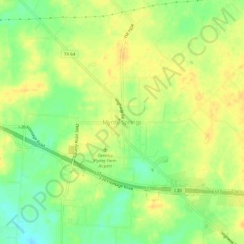
Name: Myrtle Springs topographic map, elevation, terrain.

Location: Myrtle Springs, Van Zandt County, Texas, United States (32.59045 -95.95167 32.63045 -95.91167)

Average elevation: 512 ft

Minimum elevation: 456 ft

Maximum elevation: 548 ft

Van Zandt County trails, hiking, mountain biking, running and outdoor activities

Other topographic maps

Click on a map to view its topography, its elevation and its terrain.

Fruitvale

United States > Texas > Van Zandt County

Average elevation: 446 ft

Edgewood

United States > Texas > Van Zandt County

Average elevation: 472 ft

Gear up for your next adventure:

🗺️NatGeo Topo Maps - High-quality waterproof printed topographic maps of US Parks
🪄Magnetic Compass - Accurate compass for navigation
🧭Outdoor Navigation Book - Learn advanced navigation skills
🥾Hiking Shoes - Durable and comfortable shoes for trail hiking
🔥Fast-Boil Camping Stoves - Efficient cooking systems for quick trail meals

As an Amazon Associate, this site earns from qualifying purchases at no extra cost to you.