Geolocate

Edgewood topographic map

Click on the map to display elevation.

About this map

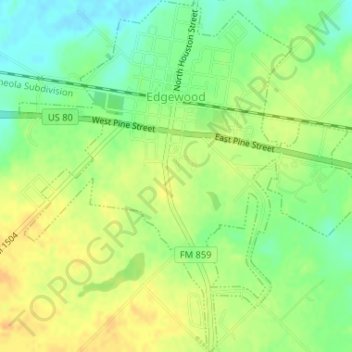
Name: Edgewood topographic map, elevation, terrain.

Location: Edgewood, Van Zandt County, Texas, United States (32.67823 -95.89977 32.70564 -95.86742)

Average elevation: 472 ft

Minimum elevation: 417 ft

Maximum elevation: 518 ft

Van Zandt County trails, hiking, mountain biking, running and outdoor activities

Other topographic maps

Click on a map to view its topography, its elevation and its terrain.

Cana

United States > Texas > Van Zandt County

Average elevation: 443 ft

Myrtle Springs

United States > Texas > Van Zandt County

Average elevation: 512 ft

Big Rock

United States > Texas > Van Zandt County

Average elevation: 515 ft

Canton

United States > Texas > Van Zandt County > Canton > Canton

Average elevation: 522 ft

Ben Wheeler

United States > Texas > Van Zandt County

Average elevation: 541 ft

Whitton

United States > Texas > Van Zandt County > Whitton

Average elevation: 456 ft

Gear up for your next adventure:

🌎3D Topographic Globes - Raised relief globes for a tactile understanding of geography
📱Solar Portable Charger - Solar power bank for charging devices off‑grid
📶Vehicle Signal Boosters - Improve reception in rural areas while driving to trailheads
🔊Portable Camp Speaker - Music and alerts at camp
🧢Sun Protection Hats - Wide-brimmed and UPF-rated hats for high-altitude sun safety

As an Amazon Associate, this site earns from qualifying purchases at no extra cost to you.