
Thank you for supporting this site ❤️
Make a donation
Make a donation
Gear up for your next adventure:
As an Amazon Associate, this site earns from qualifying purchases at no extra cost to you.
Saint-Zénon topographic map
Click on the map to display elevation.
Thank you for supporting this site ❤️
Make a donation
Make a donation
Gear up for your next adventure:
As an Amazon Associate, this site earns from qualifying purchases at no extra cost to you.
About this map
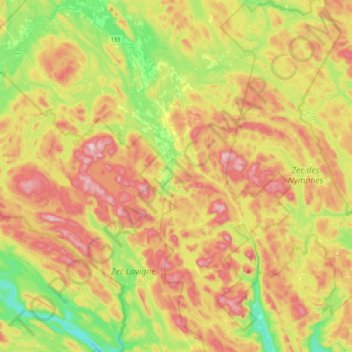
Name: Saint-Zénon topographic map, elevation, terrain.
Location: Saint-Zénon, Matawinie, Lanaudière, Quebec, J0K 3N0, Canada (46.39128 -73.93816 46.67992 -73.52299)
Average elevation: 1,601 ft
Minimum elevation: 919 ft
Maximum elevation: 2,408 ft
Thank you for supporting this site ❤️
Make a donation
Make a donation
Gear up for your next adventure:
As an Amazon Associate, this site earns from qualifying purchases at no extra cost to you.
Other topographic maps
Click on a map to view its topography, its elevation and its terrain.