
Make a donation
Gear up for your next adventure:
As an Amazon Associate, this site earns from qualifying purchases at no extra cost to you.
Fayetteville topographic map
Click on the map to display elevation.
Make a donation
Gear up for your next adventure:
As an Amazon Associate, this site earns from qualifying purchases at no extra cost to you.
Fayetteville
Fayetteville is nestled in the picturesque Ozark Mountains, characterized by rolling hills, lush forests, and scenic valleys that define the region's topography. The elevation in Fayetteville ranges from about 1,100 feet to over 1,500 feet above sea level, creating a varied landscape that features steep ridges and gentle slopes. The area is crisscrossed by numerous streams and creeks, contributing to a rich ecosystem and offering recreational opportunities such as hiking and mountain biking. The surrounding terrain is marked by limestone outcroppings and is dotted with trails that provide stunning views of the natural beauty and seasonal foliage, making Fayetteville an appealing destination for outdoor enthusiasts.
Make a donation
Gear up for your next adventure:
As an Amazon Associate, this site earns from qualifying purchases at no extra cost to you.
About this map
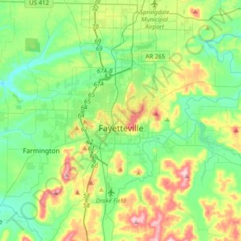
Name: Fayetteville topographic map, elevation, terrain.
Location: Fayetteville, Washington County, Arkansas, United States (35.98936 -94.29778 36.14893 -94.02671)
Average elevation: 1,316 ft
Minimum elevation: 1,066 ft
Maximum elevation: 1,906 ft
Washington County trails, hiking, mountain biking, running and outdoor activities
Make a donation
Gear up for your next adventure:
As an Amazon Associate, this site earns from qualifying purchases at no extra cost to you.
Other topographic maps
Click on a map to view its topography, its elevation and its terrain.
Make a donation
Gear up for your next adventure:
As an Amazon Associate, this site earns from qualifying purchases at no extra cost to you.
Make a donation
Gear up for your next adventure:
As an Amazon Associate, this site earns from qualifying purchases at no extra cost to you.
Make a donation
Gear up for your next adventure:
As an Amazon Associate, this site earns from qualifying purchases at no extra cost to you.