
Make a donation
Gear up for your next adventure:
As an Amazon Associate, this site earns from qualifying purchases at no extra cost to you.
Punalur topographic map
Click on the map to display elevation.
Make a donation
Gear up for your next adventure:
As an Amazon Associate, this site earns from qualifying purchases at no extra cost to you.
Punalur
Punalur has an average elevation of 56 metres (184 ft). Many tourists have visited scenic spots along the Kallada River. The Palaruvi Falls is 35 kilometres (22 mi) from Punalur. The first planned eco-tourism project in Kerala is only 20 kilometres (12 mi) from Punalur on NH 744 towards Sengottai.
Make a donation
Gear up for your next adventure:
As an Amazon Associate, this site earns from qualifying purchases at no extra cost to you.
About this map
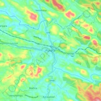
Name: Punalur topographic map, elevation, terrain.
Location: Punalur, Kollam District, Kerala, 691305, India (8.97746 76.88648 9.05746 76.96648)
Average elevation: 207 ft
Minimum elevation: 43 ft
Maximum elevation: 597 ft
Make a donation
Gear up for your next adventure:
As an Amazon Associate, this site earns from qualifying purchases at no extra cost to you.
Other topographic maps
Click on a map to view its topography, its elevation and its terrain.
Make a donation
Gear up for your next adventure:
As an Amazon Associate, this site earns from qualifying purchases at no extra cost to you.