
Make a donation
Gear up for your next adventure:
As an Amazon Associate, this site earns from qualifying purchases at no extra cost to you.
Yonne topographic map
Click on the map to display elevation.
Make a donation
Gear up for your next adventure:
As an Amazon Associate, this site earns from qualifying purchases at no extra cost to you.
Yonne
The geology of the department is complex with concentric rings of granite, Jurassic, Cretaceous and Tertiary rocks, and layers of sedimentary rocks. The terrain is mostly a low-lying plateau used for agriculture. The southwestern part is the Puisaye, which has a higher elevation and is more wooded. To the centre and east, the land inclines to the northwest where the higher land of the Tonnerrois region lies. To the east the rock is mostly limestone. The Auxerrois region is renowned for the grapes grown here, which are used in the production of Chablis wine. To the south lies the mountainous massif of Morvan, the highest parts of which are in the neighbouring department of Nièvre. The department has some forested areas but is mainly used for pasture or cultivated for wheat.
Make a donation
Gear up for your next adventure:
As an Amazon Associate, this site earns from qualifying purchases at no extra cost to you.
About this map
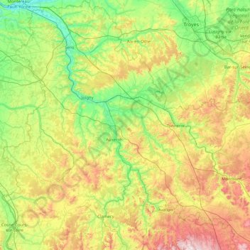
Name: Yonne topographic map, elevation, terrain.
Location: Yonne, Bourgogne – Franche-Comté, Metropolitan France, France (47.31036 2.84849 48.40006 4.34007)
Average elevation: 679 ft
Minimum elevation: 148 ft
Maximum elevation: 2,044 ft
Make a donation
Gear up for your next adventure:
As an Amazon Associate, this site earns from qualifying purchases at no extra cost to you.
Other topographic maps
Click on a map to view its topography, its elevation and its terrain.
Le Château du Bois
France > Bourgogne – Franche-Comté > Nièvre > Entrains-sur-Nohain
Average elevation: 804 ft
Sur Ilots du Bas
France > Bourgogne – Franche-Comté > Haute-Saône > Renaucourt
Average elevation: 761 ft
Make a donation
Gear up for your next adventure:
As an Amazon Associate, this site earns from qualifying purchases at no extra cost to you.
Make a donation
Gear up for your next adventure:
As an Amazon Associate, this site earns from qualifying purchases at no extra cost to you.
Les Loges de Vandenesse
France > Bourgogne – Franche-Comté > Nièvre > Saint-Honoré-les-Bains
Average elevation: 860 ft
Make a donation
Gear up for your next adventure:
As an Amazon Associate, this site earns from qualifying purchases at no extra cost to you.
Mont Auxois
France > Bourgogne – Franche-Comté > Côte-d'Or > Alise-Sainte-Reine
Average elevation: 1,007 ft
Make a donation
Gear up for your next adventure:
As an Amazon Associate, this site earns from qualifying purchases at no extra cost to you.
Make a donation
Gear up for your next adventure:
As an Amazon Associate, this site earns from qualifying purchases at no extra cost to you.
La Croix
France > Bourgogne – Franche-Comté > Saône-et-Loire > Saint-Sernin-du-Bois
Average elevation: 1,460 ft
L'Enclose
France > Bourgogne – Franche-Comté > Haute-Saône > Servance-Miellin
Average elevation: 1,857 ft
Make a donation
Gear up for your next adventure:
As an Amazon Associate, this site earns from qualifying purchases at no extra cost to you.
Le Reux
France > Bourgogne – Franche-Comté > Nièvre > Saint-Honoré-les-Bains > Tussy
Average elevation: 1,161 ft
Dardy
France > Bourgogne – Franche-Comté > Saône-et-Loire > Saint-Pierre-le-Vieux
Average elevation: 1,594 ft
Make a donation
Gear up for your next adventure:
As an Amazon Associate, this site earns from qualifying purchases at no extra cost to you.
Bierre en Morvan
France > Bourgogne – Franche-Comté > Côte-d'Or > La Roche-en-Brenil
Average elevation: 1,263 ft
Make a donation
Gear up for your next adventure:
As an Amazon Associate, this site earns from qualifying purchases at no extra cost to you.
Verdin
France > Bourgogne – Franche-Comté > Saône-et-Loire > Montagny-près-Louhans
Average elevation: 653 ft
Make a donation
Gear up for your next adventure:
As an Amazon Associate, this site earns from qualifying purchases at no extra cost to you.
Make a donation
Gear up for your next adventure:
As an Amazon Associate, this site earns from qualifying purchases at no extra cost to you.
Jardins de l'Hôtel du Département
France > Bourgogne – Franche-Comté > Jura > Lons-le-Saunier
Average elevation: 981 ft
Abbaye en Grandvaux
France > Bourgogne – Franche-Comté > Jura > Grande-Rivière-Château
Average elevation: 3,136 ft
Bois de Vaubierge
France > Bourgogne – Franche-Comté > Doubs > Montécheroux
Average elevation: 1,896 ft
Make a donation
Gear up for your next adventure:
As an Amazon Associate, this site earns from qualifying purchases at no extra cost to you.
Le Tertre
France > Bourgogne – Franche-Comté > Haute-Saône > Amont-et-Effreney
Average elevation: 1,654 ft
Make a donation
Gear up for your next adventure:
As an Amazon Associate, this site earns from qualifying purchases at no extra cost to you.
Château d'Estours
France > Bourgogne – Franche-Comté > Saône-et-Loire > Crêches-sur-Saône > Estours
Average elevation: 600 ft
Le Potin
France > Bourgogne – Franche-Comté > Nièvre > Châteauneuf-Val-de-Bargis
Average elevation: 984 ft
Saint-Valère
France > Bourgogne – Franche-Comté > Haute-Saône > Port-sur-Saône
Average elevation: 804 ft
Make a donation
Gear up for your next adventure:
As an Amazon Associate, this site earns from qualifying purchases at no extra cost to you.
Le Cailleret
France > Bourgogne – Franche-Comté > Côte-d'Or > Puligny-Montrachet
Average elevation: 906 ft
Make a donation
Gear up for your next adventure:
As an Amazon Associate, this site earns from qualifying purchases at no extra cost to you.
La Roche d'Amont
France > Bourgogne – Franche-Comté > Haute-Saône > Haut-du-Them
Average elevation: 1,936 ft
Les Creux Bréçons
France > Bourgogne – Franche-Comté > Saône-et-Loire > Toulon-sur-Arroux
Average elevation: 932 ft
Make a donation
Gear up for your next adventure:
As an Amazon Associate, this site earns from qualifying purchases at no extra cost to you.
Mont Beuvray
France > Bourgogne – Franche-Comté > Saint-Léger-sous-Beuvray
Average elevation: 2,073 ft
Au Faubourg
France > Bourgogne – Franche-Comté > Côte-d'Or > Flavigny-sur-Ozerain
Average elevation: 1,243 ft
Auvillard
France > Bourgogne – Franche-Comté > Côte-d'Or > Saint-Victor-sur-Ouche
Average elevation: 1,437 ft
Make a donation
Gear up for your next adventure:
As an Amazon Associate, this site earns from qualifying purchases at no extra cost to you.
La Vieille Voie
France > Bourgogne – Franche-Comté > Haute-Saône > Corravillers
Average elevation: 1,946 ft
La Ferdière du Bas
France > Bourgogne – Franche-Comté > Saône-et-Loire > Navour-sur-Grosne
Average elevation: 1,191 ft
Make a donation
Gear up for your next adventure:
As an Amazon Associate, this site earns from qualifying purchases at no extra cost to you.
Montépile
France > Bourgogne – Franche-Comté > Jura > Septmoncel les Molunes
Average elevation: 3,186 ft
Les Grandes Vignes
France > Bourgogne – Franche-Comté > Saône-et-Loire > Prissé
Average elevation: 801 ft
Make a donation
Gear up for your next adventure:
As an Amazon Associate, this site earns from qualifying purchases at no extra cost to you.