Geolocate

La Union topographic map

Click on the map to display elevation.

La Union

Topography

Wikipedia (CC-BY-SA 3.0)

About this map

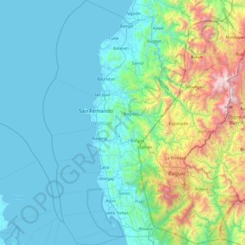
Name: La Union topographic map, elevation, terrain.

Location: La Union, Ilocos Region, Philippines (16.17666 120.13709 16.97812 120.58514)

Average elevation: 1,440 ft

Minimum elevation: 0 ft

Maximum elevation: 8,871 ft

Other topographic maps

Click on a map to view its topography, its elevation and its terrain.

Baguio

Philippines

In 1903, Filipinos, Japanese and Chinese workers were hired to build Kennon Road, the first road directly connecting Baguio with the lowlands of La Union and Pangasinan. Before this, the only road to Benguet was Naguilian Road, and it was largely a horse trail at higher elevations. Camp John Hay was…

Average elevation: 2,890 ft

Quezon City

Philippines

Founded as a pueblo by Saint Pedro Bautista in 1590, San Francisco del Monte may be considered Quezon City's oldest district. The original land area of the old town of San Francisco del Monte was approximately2.5 square kilometres (1.0 sq mi) and covered parts of what is currently known as Project 7 and 8 and…

Average elevation: 187 ft

Longlong

Philippines > Benguet > La Trinidad > Puguis

Average elevation: 4,478 ft

Cabadbaran

Philippines > Agusan del Norte

It is 29 kilometres (18 mi) from Butuan. It is generally flat with rolling hills and swamplands in its western part. The highest of all mountains in the Caraga region, Mount Hilong-Hilong (with an altitude of 2,012 metres (6,601 ft) above sea level), rises in this city.

Average elevation: 587 ft

Malainen Luma

Philippines > Cavite > Naic

Average elevation: 177 ft

Cebu City

Philippines > Cebu > Cebu City

Average elevation: 459 ft

Villanueva

Philippines > Misamis Oriental

Average elevation: 279 ft

Bacolod

Philippines

Bacólod (English: Bacolod), is derived from bakólod (Old Spelling: bacólod), the Old Hiligaynon (Old Ilonggo) (Old Spelling: Ylongo and Ilongo) word for a "hill, turtle, mound, rise, hillock, down, any small eminence or elevation", since the resettlement was founded on a stony, hilly area, now the barangay…

Average elevation: 161 ft

Panglao Island

Philippines > Bohol

Average elevation: 154 ft

Calapan

Philippines > Oriental Mindoro

The overall land characteristic is a wide plain with rivers, interspersed with wetlands at the seacoast periphery. The highest elevation is 187 m (614 ft) above sea level at Bulusan Hill, a 6-kilometre (3.7 mi) long landform east of the city, which interrupts the mostly flat terrain north-east of the…

Average elevation: 131 ft

Malolos

Philippines > Bulacan

Malolos is relatively flat of about 0.81% to a gently sloping of 2.17%. The slope of the land descends towards west, southwest to southern direction. The highest land elevation is at about 6.0 meters above sea level while the lowest is only half a meter below sea level. A network of natural waterways and…

Average elevation: 20 ft

Paombong

Philippines > Bulacan

Average elevation: 10 ft

Naguilian

Philippines > La Union

The approximate elevation of the municipality is 165 meters above sea level. It has the ninth highest approximate average elevation among the twenty (20) towns of the province. The portion with the highest elevation is 544 meters above sea level while the lowest is 10 meters. The slopes range from 2–7% in…

Average elevation: 279 ft

Bauko

Philippines > Mountain Province

Average elevation: 4,442 ft

Didicas Volcano

Philippines > Cagayan > Calayan

Didicas is topped with a lava dome with an elevation of 228 metres (748 ft) and a base diameter of 1,200 metres (3,900 ft) at sea level. It is at the southern end of the Luzon Volcanic Arc, and like all the volcanoes in the Philippines, is part of the Pacific ring of fire.

Average elevation: 23 ft

Maria Aurora

Philippines > Aurora

Average elevation: 177 ft

Dasmariñas

Philippines > Cavite

Dasmariñas is partly lowland and partly hilly. The Poblacion itself is elevated. From an elevation of 80 meters (260 ft) at the Poblacion, the land rises to 250 meters (820 ft) towards Silang. Generally, land near rivers and creeks are rugged. Dasmariñas is outside the typhoon belt and has no fault line…

Average elevation: 318 ft

Bohol

Philippines

Average elevation: 381 ft

Rizal

Philippines

Average elevation: 312 ft

Legazpi

Philippines > Albay

Legazpi's topography is generally plain on the northeastern areas, with slopes ranging from five to fifteen degrees. The southern areas have mostly rolling to hilly terrain. In the city's coastal areas, the terrain varies from plain (north) to hilly (south). Legazpi is criss-crossed by several rivers including…

Average elevation: 492 ft

San Miguel

Philippines > Bulacan

Average elevation: 72 ft

Dauin

Philippines > Negros Oriental

Average elevation: 184 ft

Virac

Philippines > Catanduanes

Average elevation: 249 ft

Kinatihan II

Philippines

Average elevation: 72 ft

Cebu

Philippines

Average elevation: 292 ft

Oas

Philippines > Albay

Average elevation: 128 ft

Estero de Vitas

Philippines > Manila

Average elevation: 16 ft

Argao

Philippines > Cebu

Average elevation: 102 ft

Cabangan

Philippines > Zambales

The municipality has a varied topography characterized by high mountains to narrow coastal plains. The most outstanding feature observable in the municipality is the Zambales Range.

Average elevation: 171 ft

Sinocalan River

Philippines > Pangasinan > Urdaneta

Average elevation: 62 ft

Talomo District

Philippines > Davao City

Average elevation: 89 ft

Poro Point

Philippines > La Union > San Fernando

Average elevation: 7 ft

Lengigon

Philippines > Cebu

Average elevation: 846 ft

Miniloc Island

Philippines > Palawan > El Nido

Average elevation: 89 ft

Santa Maria

Philippines > Laguna > Santa Maria

Average elevation: 253 ft

Montalban

Philippines > Rizal > Rodriguez

Rodriguez is generally very rough in topography, with 83% of its total land area composed of upland areas, hills and mountain ranges. The remaining 17% low-lying terrain and rolling lands are found at the south-western portion of the municipality, along with the northern portions of the Municipality of San…

Average elevation: 325 ft

Biñan

Philippines > Laguna > Biñan

Average elevation: 194 ft

Marikina

Philippines

Average elevation: 262 ft

Sugod

Philippines > Sorsogon

Average elevation: 69 ft

Narvacan

Philippines > Ilocos Sur

Average elevation: 49 ft

Passi

Philippines > Iloilo

Average elevation: 266 ft

Dumanjug

Philippines > Cebu

Average elevation: 164 ft

Cupang

Philippines > Rizal

Average elevation: 220 ft

Cabugao

Philippines > Ilocos Sur

Average elevation: 82 ft

Cuyago

Philippines > Agusan del Norte

Average elevation: 292 ft

Batanes

Philippines

Average elevation: 85 ft

Samar

Philippines

Average elevation: 125 ft

Aborlan

Philippines > Palawan

Average elevation: 43 ft

Las Piñas

Philippines

Average elevation: 46 ft

Pavia

Philippines > Iloilo

Average elevation: 52 ft

Lubao

Philippines > Pampanga

Average elevation: 13 ft

Peñablanca

Philippines > Cagayan

Average elevation: 174 ft

Toledo

Philippines > Cebu

Average elevation: 351 ft

Tanay

Philippines > Rizal

Average elevation: 105 ft

Mangaldan

Philippines > Pangasinan

Average elevation: 20 ft

Dasol

Philippines > Pangasinan

Average elevation: 112 ft

Tagoloan

Philippines > Misamis Oriental

Average elevation: 72 ft

Lapu-Lapu

Philippines

Average elevation: 305 ft

Dagupan

Philippines > Pangasinan

Average elevation: 39 ft

Patag Island

Philippines

Average elevation: 0 ft

Kota Island

Philippines

Average elevation: 0 ft

Lankiam Cay

Philippines

Average elevation: 0 ft

Iriga

Philippines

Average elevation: 377 ft

Davao Gulf

Philippines

Average elevation: 0 ft

San Juan

Philippines

"San Juan" is a contraction of the city's traditional name of "San Juan del Monte" (lit. 'Saint John of the Mountain'). As with numerous other places in the Philippines, the name combines a patron saint and a toponym; in this case Saint John the Baptist with the locale's hilly terrain and relatively higher…

Average elevation: 115 ft

Lawak Island

Philippines

Average elevation: 0 ft

Surigao del Sur

Philippines

Average elevation: 899 ft

Candaba

Philippines

Average elevation: 20 ft

Davao City

Philippines

Average elevation: 213 ft

Ibabang Bukal

Philippines

Average elevation: 833 ft

Cabatang

Philippines

Average elevation: 1,099 ft

Pinget

Philippines

Average elevation: 4,692 ft

Caloocan

Philippines

Average elevation: 266 ft

Aurora Hill North Central

Philippines

Average elevation: 4,852 ft

Besigan

Philippines

Average elevation: 1,916 ft

Talomo River

Philippines

Average elevation: 659 ft

Asin

Philippines

Average elevation: 4,334 ft

Catambungan

Philippines

Average elevation: 16 ft

Tablas Strait

Philippines

Average elevation: 0 ft

Buenavista

Philippines

Average elevation: 367 ft

Poliwes

Philippines

Average elevation: 4,583 ft

Teodora Alonzo

Philippines

Average elevation: 4,787 ft

Manggahan

Philippines

Average elevation: 23 ft

Bakakeng Norte

Philippines

Average elevation: 4,524 ft

New Carmen

Philippines

Average elevation: 322 ft

Crossing Bayabas

Philippines

Average elevation: 72 ft

Taguig

Philippines

Average elevation: 128 ft

Marinduque

Philippines

Average elevation: 177 ft

Bakakeng Central

Philippines

Average elevation: 4,633 ft

Tarlac

Philippines

Average elevation: 358 ft

Parañaque

Philippines

Average elevation: 46 ft

Pasig

Philippines

Average elevation: 151 ft

Pacdal

Philippines

Average elevation: 4,751 ft

Macasandig

Philippines

Average elevation: 138 ft

Nueva Ecija

Philippines

Average elevation: 367 ft

Nueva Vizcaya

Philippines

Average elevation: 351 ft

Antique

Philippines

Average elevation: 151 ft

Zone IV

Philippines

Average elevation: 13 ft

Albay

Philippines

Average elevation: 157 ft

Gear up for your next adventure:

🛡️Insect Repellent - Protection against bugs during outdoor activities
📦Dry Bags Set - Waterproof storage for electronics and clothes
🧤Tactile Hiking Gloves - Keep hands warm while operating GPS and smartphone screens
Backpacking Tents - Weight-optimized shelters for multi-day topographic surveys
🦺Reflective Outdoor Gear - Safety gear for low‑light conditions

As an Amazon Associate, this site earns from qualifying purchases at no extra cost to you.