
Make a donation
Gear up for your next adventure:
As an Amazon Associate, this site earns from qualifying purchases at no extra cost to you.
Masbate topographic map
Click on the map to display elevation.
Make a donation
Gear up for your next adventure:
As an Amazon Associate, this site earns from qualifying purchases at no extra cost to you.
About this map
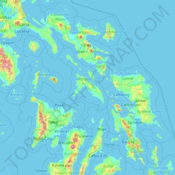
Name: Masbate topographic map, elevation, terrain.
Location: Masbate, Bicol Region, Philippines (9.56667 120.98333 14.76667 126.18333)
Average elevation: 177 ft
Minimum elevation: -7 ft
Maximum elevation: 7,966 ft
Make a donation
Gear up for your next adventure:
As an Amazon Associate, this site earns from qualifying purchases at no extra cost to you.
Other topographic maps
Click on a map to view its topography, its elevation and its terrain.
Metro Manila
The Coastal Margin or Lowland is a flat and low plain that faces Manila Bay. Located here is Manila, Navotas, parts of Malabon, and the western part and reclaimed areas of Pasay and Parañaque, where the ground elevation ranges from zero meters on Manila Bay to five meters at the west side of the cities of…
Average elevation: 141 ft
Batangas
Batangas is a combination of plains and mountains, including one of the world's smallest volcanoes, Mt. Taal, with an elevation of 600 metres (2,000 ft), located in the middle of the Taal Lake. Other important peaks are Mount Macolod with an elevation of 830 metres (2,720 ft), Mt. Banoy with 960 metres (3,150…
Average elevation: 413 ft
Cavite
Another theory proposes that the name is a Hispanicized form of kabit, Tagalog for "joined", "connected", or "attached", referring to the peninsula's topographical relation to the mainland. Edmund Roberts, in his 1821 memoir, stated that the "natives" called it Caveit due to the "crooked point of land…
Average elevation: 289 ft
Make a donation
Gear up for your next adventure:
As an Amazon Associate, this site earns from qualifying purchases at no extra cost to you.
Bataan
Bataan is divided by two mountain groups of volcanic origins. The northern side is composed of the Mount Natib (elevation 1,253 metres (4,111 ft)), Mount Sta. Rosa and Mount Silangan. The southern group is composed of Mount Mariveles, Mount Samat, and Mount Cuyapo. A narrow pass separates these two mountain…
Average elevation: 230 ft
Quezon City
In order to make Quezon's dream a reality and to mobilize funds for the land purchase, the People's Homesite Corporation (PHC) was created on October 14, 1938, as a subsidiary of NDC, with an initial capital of ₱2 million. Roces was the chairman of the Board of PHC, and they immediately acquired the vast…
Average elevation: 128 ft
Make a donation
Gear up for your next adventure:
As an Amazon Associate, this site earns from qualifying purchases at no extra cost to you.
Nueva Ecija
The province is the largest in Central Luzon, covering a total area of 5,751.33 square kilometres (2,220.60 sq mi). Its terrain begins with the southwestern marshes near the Pampanga border. It levels off and then gradually increases in elevation to rolling hills as it approaches the mountains of Sierra Madre…
Average elevation: 902 ft
Muntinlupa
There are three plausible origins of the name of the city: First, is its association with the thin topsoil in the area; second, residents, purportedly replying to a question by Spaniards in the 16th century what the name of their place was, said “Monte sa Lupa”—apparently mistaking the question for what…
Average elevation: 69 ft
Make a donation
Gear up for your next adventure:
As an Amazon Associate, this site earns from qualifying purchases at no extra cost to you.
Make a donation
Gear up for your next adventure:
As an Amazon Associate, this site earns from qualifying purchases at no extra cost to you.
Make a donation
Gear up for your next adventure:
As an Amazon Associate, this site earns from qualifying purchases at no extra cost to you.
Angeles
Sapangbato is the largest barangay in Angeles in terms of territory, with a total land area of 104,694 sq. meters and a population of 11,262. Located northwest of Angeles near Clark Freeport Zone, it is identified as the barangay in Angeles with the highest elevation of 750 feet above sea level. It is home to…
Average elevation: 322 ft
Mandaue
It is one of the two (the other one being the municipality of Consolacion) local government units located within the mainland Metro Cebu where the elevation of land is less than 100 m (330 ft).
Average elevation: 102 ft
Make a donation
Gear up for your next adventure:
As an Amazon Associate, this site earns from qualifying purchases at no extra cost to you.
Make a donation
Gear up for your next adventure:
As an Amazon Associate, this site earns from qualifying purchases at no extra cost to you.
Batangas City
The city is the center of the radio listening market in Batangas, and is served by local radio stations, as well as some radio stations from Lipa and other parts of the Mega Manila area. The Roman Catholic Archdiocese of Lipa, through the Radyo Bayanihan System, hosts two local radio stations: ALFM 95.9 Radyo…
Average elevation: 213 ft
Masbate
The general surface configuration of the province ranges from slightly undulating to rolling and from hilly to mountainous. In each island, the rugged topography is concentrated in the northeastern portion and gradually recedes to blunt hills and rolling areas in the south, southeast, and southwest.
Average elevation: 92 ft
Mindoro
Philippines > Occidental Mindoro
Mindoro is the seventh largest and eighth-most populous island in the Philippines. With a total land area of 10,571 km2 ( 4,082 sq.mi ) and has a population of 1,408,454 as of 2020 census. It is located off the southwestern coast of Luzon and northeast of Palawan. Mindoro is divided into two provinces:…
Average elevation: 568 ft
Make a donation
Gear up for your next adventure:
As an Amazon Associate, this site earns from qualifying purchases at no extra cost to you.
Metro Manila
The Coastal Margin or Lowland is a flat and low plain that faces Manila Bay. Located here is Manila, Navotas, parts of Malabon, and the western part and reclaimed areas of Pasay and Parañaque, where the ground elevation ranges from zero meters on Manila Bay to five meters at the west side of the cities of…
Average elevation: 141 ft
Make a donation
Gear up for your next adventure:
As an Amazon Associate, this site earns from qualifying purchases at no extra cost to you.
Cauayan
Philippines > Negros Occidental
The municipality of Cauayan has a rugged topography. Mt. Malipantao, considered the highest peak in the province, separates the municipality from the town of Candoni and the city of Sipalay. Portion of the ranges are the remaining thick forest that needs protection where the watershed is located. The remaining…
Average elevation: 305 ft
Negros Occidental
Negros Occidental has a tropical climate due to the fact that it is situated close to the equator, being located at least nine degrees north of it. The northern section of the province has a tropical rainforest (Köppen: Af) climate, whereas the southern portion has a tropical monsoon (Köppen: Am) climate.…
Average elevation: 413 ft
Make a donation
Gear up for your next adventure:
As an Amazon Associate, this site earns from qualifying purchases at no extra cost to you.
Kibawe
Kibawe is a rich land at the center of Mindanao, located in southern Bukidnon. It is bounded in the north by the municipality of Dangcagan, on the south by the municipality of Damulog, on the east by the municipality of Magpet, North Cotabato, and on the west by the municipality of Kadingilan with Muleta River…
Average elevation: 876 ft
Make a donation
Gear up for your next adventure:
As an Amazon Associate, this site earns from qualifying purchases at no extra cost to you.
Mindanao
In the eastern portion of the island, from Bilas Point in Surigao del Norte to Cape San Agustin in Davao Oriental, is a range of complex mountains known in their northern portion as the Diwata Mountains. This range is low and rolling in its central portion. A proposed road connecting Bislig on the east coast…
Average elevation: 177 ft
Make a donation
Gear up for your next adventure:
As an Amazon Associate, this site earns from qualifying purchases at no extra cost to you.
Luisiana
Locals call the town Little Amigos Dísmo because of its high elevation and cool climate like the City of Baguio.
Average elevation: 984 ft
Make a donation
Gear up for your next adventure:
As an Amazon Associate, this site earns from qualifying purchases at no extra cost to you.
Siquijor
The island lies about 19 kilometres (12 mi) east of the nearest point on southern Negros, 25 kilometres (16 mi) southeast of Cebu, 30 kilometres (19 mi) southwest of Bohol, and 45 kilometres (28 mi) north of Zamboanga del Norte in Mindanao. It is predominantly hilly and in many places the hills reach the sea,…
Average elevation: 56 ft
Make a donation
Gear up for your next adventure:
As an Amazon Associate, this site earns from qualifying purchases at no extra cost to you.
Make a donation
Gear up for your next adventure:
As an Amazon Associate, this site earns from qualifying purchases at no extra cost to you.
Aurora
The province covers a portion of the Sierra Madre mountain range. As such, the elevation is generally steep to very steep and only about 14% of the province's total area is flat.
Average elevation: 837 ft
Catanduanes
The topography of Catanduanes Island is rugged and mountainous, becoming more pronounced towards the central portion of the island. Less than 10 percent of the land area has a slope gradient under 8 percent, mostly fractured and narrow strips of plains located along the coastal areas where most of the…
Average elevation: 115 ft
Busuanga
Elevation The municipality's western and central portions are predominantly rough and mountainous with rolling to hilly terrain. A part of this is the Chinabayan Mountain and Wayan Range that still support extensive parches of Molave forest and Cogon grassland (features which are dominant in the locale).…
Average elevation: 52 ft
Isabela
The province is divided into three physiographic areas. The eastern area, straddled by the Sierra Madre mountain range, is rugged and thickly forested. A substantial portion is uncharted. These unexplored hinterlands are home to a rich variety of flora and fauna, and some are under government reservations. It…
Average elevation: 745 ft
Make a donation
Gear up for your next adventure:
As an Amazon Associate, this site earns from qualifying purchases at no extra cost to you.
Antique
Mount Madja-as is located in Culasi, is the highest peak on the island of Panay. This 2,117-metre-high (6,946 ft) mountain is a dormant volcano with lakes and 14 waterfalls. It is said to be the legendary home of Bulalakaw, the supreme god of the ancients, and beckons as a challenge for hikers and trekkers.…
Average elevation: 174 ft
Laguna
Laguna is home to 24 mountains, most of which are inactive volcanoes. The highest peak in Laguna is Mt. Banahaw, with an elevation of 2,170 m (7,120 ft). Banahaw, unlike most other volcanoes in Laguna, is an active complex stratovolcano, which last erupted in 1843. Banahaw is located in the boundary of Laguna…
Average elevation: 600 ft
Make a donation
Gear up for your next adventure:
As an Amazon Associate, this site earns from qualifying purchases at no extra cost to you.
Quezon
Rugged terrains characterize the province's topography with few plains, valleys, and swamps. The Sierra Madre Mountain Range runs along the entire length of the area, with Mount Banahaw (an active volcano) rising at 2,169 meters above sea level. Only narrow strips of land along the coast and river valleys are…
Average elevation: 276 ft
Northern Mindanao
Northern Mindanao has a total land area of 2,049,602 hectares (5,064,680 acres). More than 60% of Northern Mindanao's total land area are classified as forest land. Its seas abound with fish and other marine products. The abundant vegetation, natural springs and high elevation contribute to the region's cool,…
Average elevation: 1,168 ft
Cagayan de Oro
Cagayan de Oro, located along the north-central coast of Mindanao, Philippines, encompasses a diverse topography that significantly influences its terrain. The city spans approximately 488.86 square kilometers (188.75 square miles), featuring a 25-kilometer (16 miles) coastline along Macajalar Bay. The…
Average elevation: 735 ft
Make a donation
Gear up for your next adventure:
As an Amazon Associate, this site earns from qualifying purchases at no extra cost to you.
Make a donation
Gear up for your next adventure:
As an Amazon Associate, this site earns from qualifying purchases at no extra cost to you.
Montalban
Rodriguez is generally very rough in topography, with 83% of its total land area composed of upland areas, hills and mountain ranges. The remaining 17% low-lying terrain and rolling lands are found at the south-western portion of the municipality, along with the northern portions of the Municipality of San…
Average elevation: 755 ft
Mount Kanlaon Natural Park
Philippines > Negros Occidental > San Carlos
Kanlaon, also known as Mount Kanlaon and Kanlaon Volcano (Hiligaynon: Bolkang Kanglaon; Cebuano: Bolkang Kanglaon; Filipino: Bulkang Kanlaon), is an active stratovolcano and the highest mountain on the island of Negros in the Philippines, as well as the highest point in the Visayas, with an elevation of 2,465…
Average elevation: 2,133 ft
Chico River
The Chico River, has a total length of 233 kilometres (145 mi), making it the longest tributary of the Cagayan River, itself the largest river in the Philippines. For centuries it has been central to farming, trading, livelihoods, and daily life, whether as a benefit or hindrance. It provided a source of water…
Average elevation: 1,919 ft
Make a donation
Gear up for your next adventure:
As an Amazon Associate, this site earns from qualifying purchases at no extra cost to you.
Zamboanga City
The overall topography of the city could be described as rolling to very steep. There are some flat lands, mostly narrow strips along the east coast. The urban center is mostly flat with a gentle slope to the interior, ranging from 0% to 3%. A portion, about 38,000 hectares, has slopes ranging from 18% to 30%.…
Average elevation: 256 ft
Valenzuela
The highest elevation point is 38 metres (125 ft) above sea level. Having a surface gradient of 0.55% and a gentle slope, hilly landscape is located in the industrial section of the city in Canumay. The average elevation point is 2 metres (6.6 ft) above sea level.
Average elevation: 43 ft
Make a donation
Gear up for your next adventure:
As an Amazon Associate, this site earns from qualifying purchases at no extra cost to you.
Negros Occidental
Negros Occidental has a tropical climate due to the fact that it is situated close to the equator, being located at least nine degrees north of it. The northern section of the province has a tropical rainforest (Köppen: Af) climate, whereas the southern portion has a tropical monsoon (Köppen: Am) climate.…
Average elevation: 413 ft
Make a donation
Gear up for your next adventure:
As an Amazon Associate, this site earns from qualifying purchases at no extra cost to you.
Lake Lanao
The lake has great hydroelectric potential due to its 700 meter elevation, and as such, in 1950, the Philippines National Power Corporation (NAPOCOR) began the construction of a series of hydroelectric plants titled Agus I – Agus VII along the Agus River system, which generates 70% of the electricity used by…
Average elevation: 2,582 ft
Marinduque
The highest peak in Marinduque is Mount Malindig (formerly called Mt. Marlanga), a potentially active stratovolcano with an elevation of 1,157 metres (3,796 ft) above sea level, located at the southern tip of the island.
Average elevation: 125 ft
Sorsogon
The province has an irregular topography. Except for landlocked Irosin, all the towns lie along the coast. They are all connected by concrete and asphalt roads. Mountain's sprawl over the northeast, southeast and west portions. Mount Bulusan, the tallest peak, rises 1,560 metres (5,120 ft) above sea level.
Average elevation: 167 ft
Make a donation
Gear up for your next adventure:
As an Amazon Associate, this site earns from qualifying purchases at no extra cost to you.
Capiz
Capiz covers a total area of 2,594.64 square kilometres (1,001.80 sq mi) occupying the northeastern portion of Panay Island, and is one of the five provinces that compose the Western Visayas region. Mount Nangtud, is the highest mountain in Capiz with an elevation of 6,804 ft (2,074 m) located in the…
Average elevation: 404 ft
Tarlac
Like the rest of Central Luzon, the province has three distinct seasons: summer from March to June, monsoon rain from July to early October, and monsoon winter from late October to February. Summer months, especially during May bring frequent, sometimes severe, thunderstorms with high winds, thunder, and hail.…
Average elevation: 712 ft
Make a donation
Gear up for your next adventure:
As an Amazon Associate, this site earns from qualifying purchases at no extra cost to you.
Caraga
Father Saturnino Urios University, was founded by Caraga's most loved Spanish missionary, Fr. Saturnino Urios S.J. in 1990. The Commission on Higher Education (CHED) recognized Father Saturnino Urios University as one of the best schools in the region producing top notchers in national board examinations in…
Average elevation: 446 ft
Carmona
The topography of Carmona is generally flat to strongly rolling or sloping, partly lowland and partly hill. Carmona is divided into four physiographical areas: the lowest lowland area, the lowland area, the central hilly area and the upland mountainous area.
Average elevation: 184 ft
Southern Leyte
Along with other mountain forms in the province, Mount Nacolod in Hinunangan town has the highest peak with an elevation of 948 metres (3,110 ft) above sea level. Young volcanic rocks are discovered in the terrain areas, which cover the top of the southern mountain ranges of Mount Cabalian in the Pacific Area…
Average elevation: 217 ft
Make a donation
Gear up for your next adventure:
As an Amazon Associate, this site earns from qualifying purchases at no extra cost to you.