
Albeștii Ungureni topographic map
Interactive map
Click on the map to display elevation.
About this map
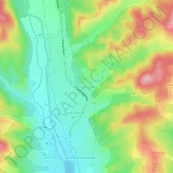
Name: Albeștii Ungureni topographic map, elevation, terrain.
Location: Albeștii Ungureni, Albeștii de Argeș, Argeș, 117006, Romania (45.20293 24.64975 45.24293 24.68975)
Average elevation: 1,781 ft
Minimum elevation: 1,499 ft
Maximum elevation: 2,234 ft
Other topographic maps
Click on a map to view its topography, its elevation and its terrain.
Mârghia de Jos
Mârghia de Jos, Lunca Corbului, Argeș, 117441, Romania
Average elevation: 869 ft
Deagu de Sus
Romania > Argeș > Deagu de Sus
Deagu de Sus, Argeș, 117622, Romania
Average elevation: 650 ft